
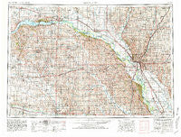
~ Sioux City IA topo map, 1:250000 scale, 1 X 2 Degree, Historical, 1955, updated 1981
Sioux City, Iowa, USGS topographic map dated 1955.
Includes geographic coordinates (latitude and longitude). This topographic map is suitable for hiking, camping, and exploring, or framing it as a wall map.
Printed on-demand using high resolution imagery, on heavy weight and acid free paper, or alternatively on a variety of synthetic materials.
Topos available on paper, Waterproof, Poly, or Tyvek. Usually shipping rolled, unless combined with other folded maps in one order.
- Product Number: USGS-5283861
- Free digital map download (high-resolution, GeoPDF): Sioux City, Iowa (file size: 18 MB)
- Map Size: please refer to the dimensions of the GeoPDF map above
- Weight (paper map): ca. 55 grams
- Map Type: POD USGS Topographic Map
- Map Series: HTMC
- Map Verison: Historical
- Cell ID: 69032
- Scan ID: 175547
- Imprint Year: 1981
- Woodland Tint: Yes
- Photo Revision Year: 1980
- Aerial Photo Year: 1978
- Edit Year: 1980
- Field Check Year: 1955
- Datum: NAD27
- Map Projection: Transverse Mercator
- Map published by United States Geological Survey
- Map Language: English
- Scanner Resolution: 600 dpi
- Map Cell Name: Sioux City
- Grid size: 1 X 2 Degree
- Date on map: 1955
- Map Scale: 1:250000
- Geographical region: Iowa, United States
Neighboring Maps:
All neighboring USGS topo maps are available for sale online at a variety of scales.
Spatial coverage:
Topo map Sioux City, Iowa, covers the geographical area associated the following places:
- Obert - Homer - Bloomfield - Winside - Hill Side - Albaton - Belden - Tabor - Meckling - Waterbury - Bazile Mills - South Yankton - Crathorne - Burbank - Volin - Decatur - Fairview Heights - Merrill - Foster - Crofton - Plymouth (historical) - Plainview - Tallview Terrace Mobile Home Park - Riverside - Ireton - North Shore - Norfolk Mobile Home Community - McCook Lake - Lodi - Mackels Mobile Home Court - Marshalltown (historical) - Midland - East End Tailer Court - Jefferson - Climbing Hill - Running Water - Wakefield - Nora - Moville - Craig - Rosalie - Richland - Wren - McNally - Norfolk - Maskell - Pilger - Center - Basford (historical) - Emerson - Carnes - Bronson - Allen - Hoffmans Trailer Court - Seney - Spink - Adaville - Nacora - Utica - Brookdale - Gayville - Hornick - Parkview Terrace - Bon Homme Colony - Kingsburg - Wee Town - Freeway Homes - Erdmann Trailer Court - Tilden - Dalesburg - Sergeant Bluff - Bow Valley Mills - Westfield - Osmond - Maple Landing (historical) - Sloan - Covington (historical) - Springdale - Macy - Westreville - Bancroft - Clay Point - Holiday Village - Napa Junction - Luton - Twilight Trailer Court - Magnet - Winnetoon - Hubbard - Wausa - Brunswick - Millnerville - Leeds - Kennebec - Hartington - Northshore Development - Alton - Saint Johns Trailer Court - Dakota City - Junction City
- Map Area ID: AREA4342-98-96
- Northwest corner Lat/Long code: USGSNW43-98
- Northeast corner Lat/Long code: USGSNE43-96
- Southwest corner Lat/Long code: USGSSW42-98
- Southeast corner Lat/Long code: USGSSE42-96
- Northern map edge Latitude: 43
- Southern map edge Latitude: 42
- Western map edge Longitude: -98
- Eastern map edge Longitude: -96


