
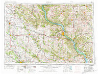
~ Dubuque IA topo map, 1:250000 scale, 1 X 2 Degree, Historical, 1976, updated 1976
Dubuque, Iowa, USGS topographic map dated 1976.
Includes geographic coordinates (latitude and longitude). This topographic map is suitable for hiking, camping, and exploring, or framing it as a wall map.
Printed on-demand using high resolution imagery, on heavy weight and acid free paper, or alternatively on a variety of synthetic materials.
Topos available on paper, Waterproof, Poly, or Tyvek. Usually shipping rolled, unless combined with other folded maps in one order.
- Product Number: USGS-5283839
- Free digital map download (high-resolution, GeoPDF): Dubuque, Iowa (file size: 18 MB)
- Map Size: please refer to the dimensions of the GeoPDF map above
- Weight (paper map): ca. 55 grams
- Map Type: POD USGS Topographic Map
- Map Series: HTMC
- Map Verison: Historical
- Cell ID: 68757
- Scan ID: 174552
- Imprint Year: 1976
- Woodland Tint: Yes
- Survey Year: 1958
- Datum: Unstated
- Map Projection: Transverse Mercator
- Map published by United States Army Corps of Engineers
- Map published by United States Army
- Map Language: English
- Scanner Resolution: 600 dpi
- Map Cell Name: Dubuque
- Grid size: 1 X 2 Degree
- Date on map: 1976
- Map Scale: 1:250000
- Geographical region: Iowa, United States
Neighboring Maps:
All neighboring USGS topo maps are available for sale online at a variety of scales.
Spatial coverage:
Topo map Dubuque, Iowa, covers the geographical area associated the following places:
- Hale - Ryan - East Rickardsville - Linden - Palo - Ozark (historical) - Paralta - Ballyclough - Ipswich - Motor - Oelwein - Platteville - Viola - Waubeek - Coggon - Saint Olaf - Bennettsville - Whitton - Lancaster - Shady Dell - La Motte - Millrock - Andrew - Osborne - Bernard - Peosta - Marion - Cornelia - Guttenberg - Montfort - Cass - Toddville - Arthur - North Buena Vista - Union - Junction Switch - Lima - Twin Springs - Robins - Hanover - Reeceville - North Bellevue - Samoa - Wilkins - King - Sherrill - Table Mound Mobile Home Park - Colesburg - Gears Ferry - Prairieburg - Amber - Delmar - Osterdock - Downers Grove - New Vienna - Lancaster Junction - Savanna - Linn Junction - Turkey River - Saint Donatus - Urbana - North Hanover - Wyalusing - Scales Mound - Millville Siding - Livingston - Galena - Lore Mobile Home Park - Massbach - Ceres - Wood - Clay Mills - Argo Fay - Oneida - Hurstville - Millville - Pleasant Valley - Maquoketa - Rockaway (historical) - Donnan - Rice - Cuba City - Waldwick - Ebys Mill - Woodland Valley Courts - Diamond Grove - Jamestown - Pleasant Hill (historical) - Springville - East Iron Hills - Millbrig (historical) - Spragueville - Van Buren - Annaton - Johnson (historical) - Covington - Elizabeth - Gilt Edge - Lakeview Mobile Home Court - J and J Mobile Home Park
- Map Area ID: AREA4342-92-90
- Northwest corner Lat/Long code: USGSNW43-92
- Northeast corner Lat/Long code: USGSNE43-90
- Southwest corner Lat/Long code: USGSSW42-92
- Southeast corner Lat/Long code: USGSSE42-90
- Northern map edge Latitude: 43
- Southern map edge Latitude: 42
- Western map edge Longitude: -92
- Eastern map edge Longitude: -90


