
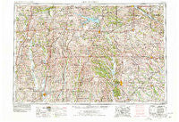
~ Centerville IA topo map, 1:250000 scale, 1 X 2 Degree, Historical, 1954, updated 1978
Centerville, Iowa, USGS topographic map dated 1954.
Includes geographic coordinates (latitude and longitude). This topographic map is suitable for hiking, camping, and exploring, or framing it as a wall map.
Printed on-demand using high resolution imagery, on heavy weight and acid free paper, or alternatively on a variety of synthetic materials.
Topos available on paper, Waterproof, Poly, or Tyvek. Usually shipping rolled, unless combined with other folded maps in one order.
- Product Number: USGS-5283819
- Free digital map download (high-resolution, GeoPDF): Centerville, Iowa (file size: 20 MB)
- Map Size: please refer to the dimensions of the GeoPDF map above
- Weight (paper map): ca. 55 grams
- Map Type: POD USGS Topographic Map
- Map Series: HTMC
- Map Verison: Historical
- Cell ID: 68706
- Scan ID: 174285
- Imprint Year: 1978
- Woodland Tint: Yes
- Photo Revision Year: 1977
- Aerial Photo Year: 1975
- Edit Year: 1977
- Datum: Unstated
- Map Projection: Transverse Mercator
- Map published by United States Geological Survey
- Map Language: English
- Scanner Resolution: 600 dpi
- Map Cell Name: Centerville
- Grid size: 1 X 2 Degree
- Date on map: 1954
- Map Scale: 1:250000
- Geographical region: Iowa, United States
Neighboring Maps:
All neighboring USGS topo maps are available for sale online at a variety of scales.
Spatial coverage:
Topo map Centerville, Iowa, covers the geographical area associated the following places:
- North Salem - Moravia - Carbon - Novelty - Troy Mills - Judson - Confidence - Omaha - Allerton - Maine - Le Roy - Akron - Julesburg - Glenwood Junction - Bairdston - Milan - Selection - Woodland - Morgan - West Grove - Saint John - Bethelhem - Burrows - Garfield - New York - Terre Haute - Thirty - Bellair (historical) - Sorrell - Waneta - Cookman - Garden Grove - Groveland (historical) - Goshen - Last Chance - Mendota - Sidney - Bute - Blythedale - Ovia - Pleasant View (historical) - Queen City - Glenwood - Darbyville - Danforth - Shott - Trenton - Haseville - Paultown - Winigan - Esper - Stahl - Tuskeego - Shibleys Point - Arbela - Unionville - Dinsmore - Pearl City - Derby - Gardner - Eldon - Troy - Iconium - Cleopatra - Greentop - Enterprise - Blue Ridge - Brashear - Princeton - Dart - Cambria - Energy - Jacksonville - Germania - Paris - Modena - Mendota (historical) - Van Wert - Streepy - Grand River - Lacelle - Brazil - Hedge City - Nind - Connelsville - Lickskillet - Mines - Pronax (historical) - Davis City - Dover (historical) - Clarkdale - Jameson - Green City - Bunker Hill - Peoria - Graysville - Willmathsville - Pollock - Tipperary - Rosewood
- Map Area ID: AREA4140-94-92
- Northwest corner Lat/Long code: USGSNW41-94
- Northeast corner Lat/Long code: USGSNE41-92
- Southwest corner Lat/Long code: USGSSW40-94
- Southeast corner Lat/Long code: USGSSE40-92
- Northern map edge Latitude: 41
- Southern map edge Latitude: 40
- Western map edge Longitude: -94
- Eastern map edge Longitude: -92


