
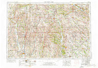
~ Centerville IA topo map, 1:250000 scale, 1 X 2 Degree, Historical, 1954, updated 1976
Centerville, Iowa, USGS topographic map dated 1954.
Includes geographic coordinates (latitude and longitude). This topographic map is suitable for hiking, camping, and exploring, or framing it as a wall map.
Printed on-demand using high resolution imagery, on heavy weight and acid free paper, or alternatively on a variety of synthetic materials.
Topos available on paper, Waterproof, Poly, or Tyvek. Usually shipping rolled, unless combined with other folded maps in one order.
- Product Number: USGS-5283817
- Free digital map download (high-resolution, GeoPDF): Centerville, Iowa (file size: 20 MB)
- Map Size: please refer to the dimensions of the GeoPDF map above
- Weight (paper map): ca. 55 grams
- Map Type: POD USGS Topographic Map
- Map Series: HTMC
- Map Verison: Historical
- Cell ID: 68706
- Scan ID: 174284
- Imprint Year: 1976
- Woodland Tint: Yes
- Edit Year: 1967
- Field Check Year: 1954
- Datum: Unstated
- Map Projection: Transverse Mercator
- Map published by United States Geological Survey
- Map Language: English
- Scanner Resolution: 600 dpi
- Map Cell Name: Centerville
- Grid size: 1 X 2 Degree
- Date on map: 1954
- Map Scale: 1:250000
- Geographical region: Iowa, United States
Neighboring Maps:
All neighboring USGS topo maps are available for sale online at a variety of scales.
Spatial coverage:
Topo map Centerville, Iowa, covers the geographical area associated the following places:
- Danforth - Downing - Belknap - Bullion - Last Chance - Seymour - Livonia - Leando - Stiles - Millard - Libertyville - Parkerton - Clifton - Brucewell - Buttsville - Drakesville - Grand River - Sand Hill - Mendota - Cliffland - Wyreka - Boynton - Pulaski - Russellville (historical) - Gilman City - Crawford - Groveland (historical) - Walnut City - Cleopatra - Laredo - Half Rock - Corydon - Togo (historical) - Fabius - Blockly - North Salem - Kirksville - Millport - Mercer - Stahl - Queen City - Middle Fabius - Ovia - Lancaster - Ridgeway - Lamoni - Mystic - Barrell - Hartford - Nineveh - Blythedale - Douds - Cambria - Wanetta Corner - Bethelhem - Martinstown - Melbourne - Jameson - Kingston - Paw Paw - Green Bay (historical) - Udell - Bolton - Savannah - Sticklerville - Mystic - Pleasanton - Rosewood - Galesburg - Woodland - Steuben - Hiattsville - Andover - Hocking - Sublette - Adel - Eagleville - Trenton - Bridgeport - Humphreys - Saline - High Point - Brown (historical) - Ash Grove - Garfield - Sedan - Selma - Thirty - Energy - Brashear - Novinger - Centerville - Osgood - Harvard - Lebanon - Quinn - Le Roy - Sperry - South Lineville - Highlander Mobile Home Park
- Map Area ID: AREA4140-94-92
- Northwest corner Lat/Long code: USGSNW41-94
- Northeast corner Lat/Long code: USGSNE41-92
- Southwest corner Lat/Long code: USGSSW40-94
- Southeast corner Lat/Long code: USGSSE40-92
- Northern map edge Latitude: 41
- Southern map edge Latitude: 40
- Western map edge Longitude: -94
- Eastern map edge Longitude: -92


