
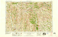
~ Centerville IA topo map, 1:250000 scale, 1 X 2 Degree, Historical, 1958
Centerville, Iowa, USGS topographic map dated 1958.
Includes geographic coordinates (latitude and longitude). This topographic map is suitable for hiking, camping, and exploring, or framing it as a wall map.
Printed on-demand using high resolution imagery, on heavy weight and acid free paper, or alternatively on a variety of synthetic materials.
Topos available on paper, Waterproof, Poly, or Tyvek. Usually shipping rolled, unless combined with other folded maps in one order.
- Product Number: USGS-5283813
- Free digital map download (high-resolution, GeoPDF): Centerville, Iowa (file size: 20 MB)
- Map Size: please refer to the dimensions of the GeoPDF map above
- Weight (paper map): ca. 55 grams
- Map Type: POD USGS Topographic Map
- Map Series: HTMC
- Map Verison: Historical
- Cell ID: 68706
- Scan ID: 174282
- Woodland Tint: Yes
- Field Check Year: 1954
- Datum: Unstated
- Map Projection: Transverse Mercator
- Map published by United States Geological Survey
- Map Language: English
- Scanner Resolution: 600 dpi
- Map Cell Name: Centerville
- Grid size: 1 X 2 Degree
- Date on map: 1958
- Map Scale: 1:250000
- Geographical region: Iowa, United States
Neighboring Maps:
All neighboring USGS topo maps are available for sale online at a variety of scales.
Spatial coverage:
Topo map Centerville, Iowa, covers the geographical area associated the following places:
- Parsons - Blockly - Decatur City - Blakesburg - Smyrna - Pulaski - Chapel - Peoria - Dunlap - Milan - Galesburg - Graysville - Plano - Hedge City - Zig - Burrows - Tindall - Cleopatra - Energy - Gardner - Greentop - Lucerne - Newtown - Greensburg - Wataga - Last Chance - Troy - Udell - Blackbird (historical) - Pennville - Lemons - Julesburg - Valley Village Mobile Home Park - Wilson - Blythedale - Saint John - Middle Fabius - Hartford - Locust Hill - Wyandotte - Carbon - Bullion - Sidney - Ovia - Hitt - Bairdston - Business Corners (historical) - Kingston - Chariton - Germania - Russell - White Elm - Coal City - Half Rock - Davis City - Vinita - Browning - Leon - Agency - Harvard - Goshen - Savannah - Lowground - Milton - South Lineville - Sorrell - Nefy (historical) - Bridgeport - Groveland (historical) - Unity - Leslie - Paris - Garden Grove - Hodge - Martinstown - Hazelville (historical) - Foster - Pleasant View (historical) - Rutledge - Enterprise - Cambria - Weldon - Woodland - Clio - Numa - Pollock - Guinn - Sublette - Zero - Gilman City - Cardy - Lindersville (historical) - Rosewood - Mark - Edinburg - Lacelle - Yarrow - Eagleville - Dinsmore - Jerome
- Map Area ID: AREA4140-94-92
- Northwest corner Lat/Long code: USGSNW41-94
- Northeast corner Lat/Long code: USGSNE41-92
- Southwest corner Lat/Long code: USGSSW40-94
- Southeast corner Lat/Long code: USGSSE40-92
- Northern map edge Latitude: 41
- Southern map edge Latitude: 40
- Western map edge Longitude: -94
- Eastern map edge Longitude: -92


