
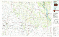
~ Oelwein IA topo map, 1:100000 scale, 30 X 60 Minute, Historical, 1984, updated 1985
Oelwein, Iowa, USGS topographic map dated 1984.
Includes geographic coordinates (latitude and longitude). This topographic map is suitable for hiking, camping, and exploring, or framing it as a wall map.
Printed on-demand using high resolution imagery, on heavy weight and acid free paper, or alternatively on a variety of synthetic materials.
Topos available on paper, Waterproof, Poly, or Tyvek. Usually shipping rolled, unless combined with other folded maps in one order.
- Product Number: USGS-5283723
- Free digital map download (high-resolution, GeoPDF): Oelwein, Iowa (file size: 15 MB)
- Map Size: please refer to the dimensions of the GeoPDF map above
- Weight (paper map): ca. 55 grams
- Map Type: POD USGS Topographic Map
- Map Series: HTMC
- Map Verison: Historical
- Cell ID: 76252
- Scan ID: 175289
- Imprint Year: 1985
- Woodland Tint: Yes
- Aerial Photo Year: 1983
- Edit Year: 1984
- Datum: NAD27
- Map Projection: Universal Transverse Mercator
- Planimetric: Yes
- Map published by United States Geological Survey
- Map Language: English
- Scanner Resolution: 600 dpi
- Map Cell Name: Oelwein
- Grid size: 30 X 60 Minute
- Date on map: 1984
- Map Scale: 1:100000
- Geographical region: Iowa, United States
Neighboring Maps:
All neighboring USGS topo maps are available for sale online at a variety of scales.
Spatial coverage:
Topo map Oelwein, Iowa, covers the geographical area associated the following places:
- Lamont - Glen Haven - Stanley - Otterville - Wadena - Saint Olaf - Illyria - Wood - Littleport - Randalia - Communia - Almoral Siding (historical) - Clayton - Thomasville - Maryville - Garber - Bagley - Millville - Lima - Garnavillo - Forestville - Taylorsville - Ceres - Oelwein - Osborne - Elkader - Oneida - Mederville - Highland - Elgin - Motor - New Vienna - Volga - Saint Sebald - Holy Cross - Almoral - Dundee - Elkport - Guttenberg - Westgate - Edgewood - Brainard - Luxemburg - York - Snefs - Fairview - Donnan - Fayette - Arlington - Clayton Center - Thorpe - Farmersburg - Aurora - Lakeview Mobile Home Court - Dutchtown - Wyalusing - Updegraff - Brodtville - Greeley - Turkey River - Eckards - Bryantsburg - Osterdock - Maynard - Petersburg - Scott - Hawkeye - Albany - Hazleton - West Union - Colesburg - Strawberry Point - Gunder - Millville Siding
- Map Area ID: AREA4342.5-92-91
- Northwest corner Lat/Long code: USGSNW43-92
- Northeast corner Lat/Long code: USGSNE43-91
- Southwest corner Lat/Long code: USGSSW42.5-92
- Southeast corner Lat/Long code: USGSSE42.5-91
- Northern map edge Latitude: 43
- Southern map edge Latitude: 42.5
- Western map edge Longitude: -92
- Eastern map edge Longitude: -91


