
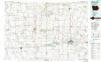
~ Mason City IA topo map, 1:100000 scale, 30 X 60 Minute, Historical, 1985, updated 1992
Mason City, Iowa, USGS topographic map dated 1985.
Includes geographic coordinates (latitude and longitude). This topographic map is suitable for hiking, camping, and exploring, or framing it as a wall map.
Printed on-demand using high resolution imagery, on heavy weight and acid free paper, or alternatively on a variety of synthetic materials.
Topos available on paper, Waterproof, Poly, or Tyvek. Usually shipping rolled, unless combined with other folded maps in one order.
- Product Number: USGS-5283715
- Free digital map download (high-resolution, GeoPDF): Mason City, Iowa (file size: 16 MB)
- Map Size: please refer to the dimensions of the GeoPDF map above
- Weight (paper map): ca. 55 grams
- Map Type: POD USGS Topographic Map
- Map Series: HTMC
- Map Verison: Historical
- Cell ID: 67917
- Scan ID: 175115
- Imprint Year: 1992
- Woodland Tint: Yes
- Photo Inspection Year: 1990
- Aerial Photo Year: 1980
- Edit Year: 1985
- Datum: NAD27
- Map Projection: Universal Transverse Mercator
- Map published by United States Geological Survey
- Map Language: English
- Scanner Resolution: 600 dpi
- Map Cell Name: Mason City
- Grid size: 30 X 60 Minute
- Date on map: 1985
- Map Scale: 1:100000
- Geographical region: Iowa, United States
Neighboring Maps:
All neighboring USGS topo maps are available for sale online at a variety of scales.
Spatial coverage:
Topo map Mason City, Iowa, covers the geographical area associated the following places:
- Ratna (historical) - Crystal Lake - Woden - Rock Falls - Mason City - Thompson - Meltonville - Hutchins - Registry Park - Lakeside Acres Mobile Park - Emery - Glade - Nora Junction - Scarville - Klemme - Kensett - Nora Springs - Miller - Leland - Lansrud - Carpenter - Joice - Hanford - Rake - Wesley - Green Meadows Mobile Home Park - Central Heights - Deer Creek - Lake Mills - Manly - Garner - Ventura - Norman (historical) - Wheelerwood - Orchard Park Mobile Home Court - Forest Park Mobile Home Court - Hawley - Plymouth Junction - Buffalo Center - Bristol - Northwood - Portland - Britt - Hanlontown - Duncan - Owen - Grafton - Hayfield Junction - Burchinal - Forest City - Bolan - Hurley - Clear Lake - Mason City Junction - Somber - Plymouth - Fertile - Vinje - Creamery - Hayfield - Silver Lake - Ventura Heights - Amund - Stilson - Freeman - Cameron
- Map Area ID: AREA43.543-94-93
- Northwest corner Lat/Long code: USGSNW43.5-94
- Northeast corner Lat/Long code: USGSNE43.5-93
- Southwest corner Lat/Long code: USGSSW43-94
- Southeast corner Lat/Long code: USGSSE43-93
- Northern map edge Latitude: 43.5
- Southern map edge Latitude: 43
- Western map edge Longitude: -94
- Eastern map edge Longitude: -93


