
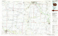
~ Marshalltown IA topo map, 1:100000 scale, 30 X 60 Minute, Historical, 1984, updated 1985
Marshalltown, Iowa, USGS topographic map dated 1984.
Includes geographic coordinates (latitude and longitude). This topographic map is suitable for hiking, camping, and exploring, or framing it as a wall map.
Printed on-demand using high resolution imagery, on heavy weight and acid free paper, or alternatively on a variety of synthetic materials.
Topos available on paper, Waterproof, Poly, or Tyvek. Usually shipping rolled, unless combined with other folded maps in one order.
- Product Number: USGS-5283709
- Free digital map download (high-resolution, GeoPDF): Marshalltown, Iowa (file size: 13 MB)
- Map Size: please refer to the dimensions of the GeoPDF map above
- Weight (paper map): ca. 55 grams
- Map Type: POD USGS Topographic Map
- Map Series: HTMC
- Map Verison: Historical
- Cell ID: 72646
- Scan ID: 175101
- Imprint Year: 1985
- Woodland Tint: Yes
- Aerial Photo Year: 1983
- Edit Year: 1984
- Datum: NAD27
- Map Projection: Universal Transverse Mercator
- Planimetric: Yes
- Map published by United States Geological Survey
- Map Language: English
- Scanner Resolution: 600 dpi
- Map Cell Name: Marshalltown
- Grid size: 30 X 60 Minute
- Date on map: 1984
- Map Scale: 1:100000
- Geographical region: Iowa, United States
Neighboring Maps:
All neighboring USGS topo maps are available for sale online at a variety of scales.
Spatial coverage:
Topo map Marshalltown, Iowa, covers the geographical area associated the following places:
- Clutier - Vinton - Dike - Cedar Knoll Park - Blessing - Quarry - Buckingham (historical) - La Porte City - Terrace Manor Mobile Home Court - Sky View Terrace Mobile Home Park - Sinclair - Swanton - Garrison - Shady Grove - Zaneta - Elk Run Heights - Hudson - Fern - Gladbrook - Conrad - Green Mountain - Lincoln - Sunset Village Mobile Home Park - Rockton - Raymond - Gilbertville - Southview Estates Mobile Home Park - Mooreville (historical) - Washburn - Traer - Woodland Terraces Mobile Home Park - Brandon - Starlite Mobile Home Park - North Street Mobile Home Park - Evansdale - Beaman - Dysart - Eagle Center - Grundy Center - Hicks - Marshalltown - Dinsdale - Holland - Jubilee - Rogersville - Predonia (historical) - Waterloo - Wise - Louise - Jesup - Lincoln - Maulsby - West Union (historical) - Buckingham - Reinbeck - Prairie View Acres Mobile Home Park - Benton Station (historical) - Geneva - Morrison - Riverforest Trailer Park - Voorhies - Wellsburg - Midway Trailer Court - Garwin - Le Grand - Orange - Cedar Falls Junction - Ivester - Van Horne - Eastgate Estate Park - Hilltop - Albion - Dairyville - Raymar - Elberon - Fredsville - Mount Auburn - Dietrick Mobile Home Park
- Map Area ID: AREA42.542-93-92
- Northwest corner Lat/Long code: USGSNW42.5-93
- Northeast corner Lat/Long code: USGSNE42.5-92
- Southwest corner Lat/Long code: USGSSW42-93
- Southeast corner Lat/Long code: USGSSE42-92
- Northern map edge Latitude: 42.5
- Southern map edge Latitude: 42
- Western map edge Longitude: -93
- Eastern map edge Longitude: -92


