
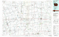
~ Iowa Falls IA topo map, 1:100000 scale, 30 X 60 Minute, Historical, 1984, updated 1985
Iowa Falls, Iowa, USGS topographic map dated 1984.
Includes geographic coordinates (latitude and longitude). This topographic map is suitable for hiking, camping, and exploring, or framing it as a wall map.
Printed on-demand using high resolution imagery, on heavy weight and acid free paper, or alternatively on a variety of synthetic materials.
Topos available on paper, Waterproof, Poly, or Tyvek. Usually shipping rolled, unless combined with other folded maps in one order.
- Product Number: USGS-5283695
- Free digital map download (high-resolution, GeoPDF): Iowa Falls, Iowa (file size: 13 MB)
- Map Size: please refer to the dimensions of the GeoPDF map above
- Weight (paper map): ca. 55 grams
- Map Type: POD USGS Topographic Map
- Map Series: HTMC
- Map Verison: Historical
- Cell ID: 67711
- Scan ID: 174888
- Imprint Year: 1985
- Woodland Tint: Yes
- Aerial Photo Year: 1983
- Edit Year: 1984
- Datum: NAD27
- Map Projection: Universal Transverse Mercator
- Planimetric: Yes
- Map published by United States Geological Survey
- Map Language: English
- Scanner Resolution: 600 dpi
- Map Cell Name: Iowa Falls
- Grid size: 30 X 60 Minute
- Date on map: 1984
- Map Scale: 1:100000
- Geographical region: Iowa, United States
Neighboring Maps:
All neighboring USGS topo maps are available for sale online at a variety of scales.
Spatial coverage:
Topo map Iowa Falls, Iowa, covers the geographical area associated the following places:
- Sheffield - Macey - Sollberg - Reeve - Alexander - Belmond - Goodell - Hansell - Robertson - Kanawha - Olaf - Faulkner - Swaledale - Rowan - Dows - Coulter - Corwith - Popejoy - Thornton - Denhart - Nuel (historical) - Alden Station (historical) - Bradford - Holmes - Galt - Chapin - Iowa Falls - Geneva - Aredale - Cartersville - Ackley - Hampton - Eagle Grove - Dougherty - Washington - Burdette - Oakland - Latimer - Goldfield - Florence - Alden - Morhain - Cornelia - Rockwell - Clarion - Drew - Iowa Falls Junction - Meservey - Renwick - Woolstock
- Map Area ID: AREA4342.5-94-93
- Northwest corner Lat/Long code: USGSNW43-94
- Northeast corner Lat/Long code: USGSNE43-93
- Southwest corner Lat/Long code: USGSSW42.5-94
- Southeast corner Lat/Long code: USGSSE42.5-93
- Northern map edge Latitude: 43
- Southern map edge Latitude: 42.5
- Western map edge Longitude: -94
- Eastern map edge Longitude: -93


