
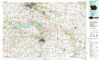
~ Iowa City IA topo map, 1:100000 scale, 30 X 60 Minute, Historical, 1984, updated 1989
Iowa City, Iowa, USGS topographic map dated 1984.
Includes geographic coordinates (latitude and longitude). This topographic map is suitable for hiking, camping, and exploring, or framing it as a wall map.
Printed on-demand using high resolution imagery, on heavy weight and acid free paper, or alternatively on a variety of synthetic materials.
Topos available on paper, Waterproof, Poly, or Tyvek. Usually shipping rolled, unless combined with other folded maps in one order.
- Product Number: USGS-5283693
- Free digital map download (high-resolution, GeoPDF): Iowa City, Iowa (file size: 23 MB)
- Map Size: please refer to the dimensions of the GeoPDF map above
- Weight (paper map): ca. 55 grams
- Map Type: POD USGS Topographic Map
- Map Series: HTMC
- Map Verison: Historical
- Cell ID: 67710
- Scan ID: 174885
- Imprint Year: 1989
- Woodland Tint: Yes
- Aerial Photo Year: 1983
- Edit Year: 1984
- Datum: NAD27
- Map Projection: Universal Transverse Mercator
- Map published by United States Geological Survey
- Map Language: English
- Scanner Resolution: 600 dpi
- Map Cell Name: Iowa City
- Grid size: 30 X 60 Minute
- Date on map: 1984
- Map Scale: 1:100000
- Geographical region: Iowa, United States
Neighboring Maps:
All neighboring USGS topo maps are available for sale online at a variety of scales.
Spatial coverage:
Topo map Iowa City, Iowa, covers the geographical area associated the following places:
- Baculis Mobile Home Park - West Park Mobile Home Village - Lake Ridge Mobile Home Park - Newhall - Sutliff - University Heights - Conroy - Perrys Rollin' Homes Manor - East Rapids - Cou Falls - Lime City - Sharon Center - Wilton - Atalissa - Tipton - East Amana - Newport - West Branch Mobile Home Village - Vernon View - Cedar Bluff - Green Castle (historical) - Walford - Springdale - Swisher - Coral Trailer Park - Atkins - West Cedar Rapids - North Liberty - Forest View Trailer Court - Holbrook - Solon - Cedar Valley - West Liberty - Parkhurst (historical) - Shueyville - Amana - Wald - Mount Vernon - Homestead - Ely - Fairfax - Summit - South Amana - Middle Amana - Rochester - Dakota Mobile Home Park - Watkins - Moscow - Golf View Mobile Home Court - Kirkwood Estates - Konigsmark - Windham - Bon-Aire Mobile Home Lodge - Graham (historical) - Twin View Heights - Frytown - Plato - Sunrise Mobile Home Village - West Amana - Breckenridge Estates - Clarence - Tipton Mobile Home Park - West Branch - Centerdale - South Towne Park - Curtis (historical) - Grand View Village - Buchanan - Lincolnway Village - Coralville - Ayresville - Norway - Bertram - Midway (historical) - Western - Colonial Estates Mobile Home Park - Mechanicsville - Elmira - Lisbon - Stanwood - Hilltop Mobile Home Park - Otis - Tiffin - Sunrise Mobile Court - Oakdale - Upper South Amana - Hometown-Cedar Terrace - Summit View Mobile Home Park - Clear Creek Mobile Home Park - Parkview Mobile Home Park - Downey - Beverly Depot - Green Center - Western Hills Mobine Estates - Oasis - Country Aire Home Park - High Amana - Amish - Holiday Mobile Home Court - Olin
- Map Area ID: AREA4241.5-92-91
- Northwest corner Lat/Long code: USGSNW42-92
- Northeast corner Lat/Long code: USGSNE42-91
- Southwest corner Lat/Long code: USGSSW41.5-92
- Southeast corner Lat/Long code: USGSSE41.5-91
- Northern map edge Latitude: 42
- Southern map edge Latitude: 41.5
- Western map edge Longitude: -92
- Eastern map edge Longitude: -91


