
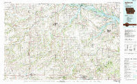
~ Indianola IA topo map, 1:100000 scale, 30 X 60 Minute, Historical, 1984, updated 1984
Indianola, Iowa, USGS topographic map dated 1984.
Includes geographic coordinates (latitude and longitude). This topographic map is suitable for hiking, camping, and exploring, or framing it as a wall map.
Printed on-demand using high resolution imagery, on heavy weight and acid free paper, or alternatively on a variety of synthetic materials.
Topos available on paper, Waterproof, Poly, or Tyvek. Usually shipping rolled, unless combined with other folded maps in one order.
- Product Number: USGS-5283691
- Free digital map download (high-resolution, GeoPDF): Indianola, Iowa (file size: 24 MB)
- Map Size: please refer to the dimensions of the GeoPDF map above
- Weight (paper map): ca. 55 grams
- Map Type: POD USGS Topographic Map
- Map Series: HTMC
- Map Verison: Historical
- Cell ID: 67706
- Scan ID: 174862
- Imprint Year: 1984
- Woodland Tint: Yes
- Aerial Photo Year: 1978
- Edit Year: 1984
- Datum: NAD27
- Map Projection: Universal Transverse Mercator
- Map published by United States Geological Survey
- Map Language: English
- Scanner Resolution: 600 dpi
- Map Cell Name: Indianola
- Grid size: 30 X 60 Minute
- Date on map: 1984
- Map Scale: 1:100000
- Geographical region: Iowa, United States
Neighboring Maps:
All neighboring USGS topo maps are available for sale online at a variety of scales.
Spatial coverage:
Topo map Indianola, Iowa, covers the geographical area associated the following places:
- Indianola - Whitebreast - Jay - Ottawa - Clarkson (historical) - Prole - Bauer - Knoxville - Ackworth - Greenbush - Greenbush - Cool - Wheel Estates Mobile Home Park - Consol - Hartford - Oakley - Woodburn - Summerset Junction (historical) - Olmitz - Osceola - Western Acres Mobile Home Park - Donnelley - Lucas - Summerset - Swan - Indianola Junction - Attica - Tipperary - Ford - Cloud - Donley Station (historical) - Purdy - New Virginia - Tileville - Liberty Center - Saint Charles - South River Crossing (historical) - Otley - Ottawa - North American Trailer Park - Conger - Lawrenceburg - Sandyville - Weller - Hartford Mobile Home Park - Pleasant Valley Mobile Home Park - Jacksonville (historical) - Hammondsburgh (historical) - Cordova - Norwalk - Spring Hill - Wensel Mobile Home Park - Chariton - West Saint Marys - Hanley - Lacona - Indiana - Sunfield Mobile Home Park - Beech - Palmyra - Pershing - Flagler - Jamison - Liberty - Cumming - Scotch Ridge - Percy (historical) - Patterson - Melcher-Dallas - Caloma - Truro - Eifield (historical) - Belinda - Gosport - McBride - Troy (historical) - Wick - Milo - Indian Ridge Mobile Home Park - Bucknell - Medora - Williamson - Martensdale - Newbern - Churchville - Colonial Terrace Mobile Home Park - Old Peru - Murray - Saint Marys - Norwood - Bevington - East Peru - Pleasantville - Columbia - Morgin Valley (historical)
- Map Area ID: AREA41.541-94-93
- Northwest corner Lat/Long code: USGSNW41.5-94
- Northeast corner Lat/Long code: USGSNE41.5-93
- Southwest corner Lat/Long code: USGSSW41-94
- Southeast corner Lat/Long code: USGSSE41-93
- Northern map edge Latitude: 41.5
- Southern map edge Latitude: 41
- Western map edge Longitude: -94
- Eastern map edge Longitude: -93


