
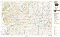
~ Harlan IA topo map, 1:100000 scale, 30 X 60 Minute, Historical, 1980, updated 1980
Harlan, Iowa, USGS topographic map dated 1980.
Includes geographic coordinates (latitude and longitude). This topographic map is suitable for hiking, camping, and exploring, or framing it as a wall map.
Printed on-demand using high resolution imagery, on heavy weight and acid free paper, or alternatively on a variety of synthetic materials.
Topos available on paper, Waterproof, Poly, or Tyvek. Usually shipping rolled, unless combined with other folded maps in one order.
- Product Number: USGS-5283681
- Free digital map download (high-resolution, GeoPDF): Harlan, Iowa (file size: 22 MB)
- Map Size: please refer to the dimensions of the GeoPDF map above
- Weight (paper map): ca. 55 grams
- Map Type: POD USGS Topographic Map
- Map Series: HTMC
- Map Verison: Historical
- Cell ID: 67634
- Scan ID: 174795
- Imprint Year: 1980
- Woodland Tint: Yes
- Aerial Photo Year: 1973
- Edit Year: 1980
- Datum: NAD27
- Map Projection: Universal Transverse Mercator
- Map published by United States Geological Survey
- Map Language: English
- Scanner Resolution: 600 dpi
- Map Cell Name: Harlan
- Grid size: 30 X 60 Minute
- Date on map: 1980
- Map Scale: 1:100000
- Geographical region: Iowa, United States
Neighboring Maps:
All neighboring USGS topo maps are available for sale online at a variety of scales.
Spatial coverage:
Topo map Harlan, Iowa, covers the geographical area associated the following places:
- Orson - Poplar - Kirkman - Poplar - Kimballton - Persia - Jacksonville - California Junction - Euclid - Dunlap - Irwin - Woodbine - Beebeetown - Magill - Manilla - Arion - Willett - Orton - Manning - Westphalia - Fiscus - Allen - Aspinwall - Hard Scratch - Elk Horn - Earling - Pisgah - Baird - Westridge Mobile Home Park - Echo - Soldier - Portsmouth - Botna - Findley - Shelby - Panama - Manteno - Missouri Valley - Dow City - Moorhead - Buck Grove - Harlan - Magnolia - Corley - Defiance - Yorkshire - Haley - Harlan Trailer Court - Calhoun - Rorbeck - Kimze - Red Line - Bell - Crisp - Union Burg (historical) - Astor - Logan - Tennant
- Map Area ID: AREA4241.5-96-95
- Northwest corner Lat/Long code: USGSNW42-96
- Northeast corner Lat/Long code: USGSNE42-95
- Southwest corner Lat/Long code: USGSSW41.5-96
- Southeast corner Lat/Long code: USGSSE41.5-95
- Northern map edge Latitude: 42
- Southern map edge Latitude: 41.5
- Western map edge Longitude: -96
- Eastern map edge Longitude: -95


