
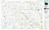
~ Guthrie Center IA topo map, 1:100000 scale, 30 X 60 Minute, Historical, 1984, updated 1985
Guthrie Center, Iowa, USGS topographic map dated 1984.
Includes geographic coordinates (latitude and longitude). This topographic map is suitable for hiking, camping, and exploring, or framing it as a wall map.
Printed on-demand using high resolution imagery, on heavy weight and acid free paper, or alternatively on a variety of synthetic materials.
Topos available on paper, Waterproof, Poly, or Tyvek. Usually shipping rolled, unless combined with other folded maps in one order.
- Product Number: USGS-5283677
- Free digital map download (high-resolution, GeoPDF): Guthrie Center, Iowa (file size: 14 MB)
- Map Size: please refer to the dimensions of the GeoPDF map above
- Weight (paper map): ca. 55 grams
- Map Type: POD USGS Topographic Map
- Map Series: HTMC
- Map Verison: Historical
- Cell ID: 67622
- Scan ID: 174777
- Imprint Year: 1985
- Woodland Tint: Yes
- Aerial Photo Year: 1983
- Edit Year: 1984
- Datum: NAD27
- Map Projection: Universal Transverse Mercator
- Planimetric: Yes
- Map published by United States Geological Survey
- Map Language: English
- Scanner Resolution: 600 dpi
- Map Cell Name: Guthrie Center
- Grid size: 30 X 60 Minute
- Date on map: 1984
- Map Scale: 1:100000
- Geographical region: Iowa, United States
Neighboring Maps:
All neighboring USGS topo maps are available for sale online at a variety of scales.
Spatial coverage:
Topo map Guthrie Center, Iowa, covers the geographical area associated the following places:
- Gray - Larland - Dale - Berkley - Bouton - Yale - Minburn - Garretville - Diamondhead Lake - Bar-Jac Mobile Estates - Brayton - Rippey - Guthrie Center - Cooper - Bagley - Menlo - Perry - Fanslers - Gardner - River Vista Trailer Park - Casey - Sharon - Winkelmans - Templeton - De Soto - Willey - Panora - Linden - Coon Rapids - Adair - Hamlin - Oakfield - Stuart - Dawson - Jamaica - Green Brier - Exira - Herndon - Viola Center - Adel - Dedham - Black Corners - Wiscotta - Kenfield - Angus - Nishna - Bayard - North Branch - Carrollton - Kennedy - Ross - Monteith - Redfield - Quarry - Gardiner - Wichita - Perry Yard - Morrisburgh (historical) - Dexter - Glendon - Audubon - Lake Panorama - Panther
- Map Area ID: AREA4241.5-95-94
- Northwest corner Lat/Long code: USGSNW42-95
- Northeast corner Lat/Long code: USGSNE42-94
- Southwest corner Lat/Long code: USGSSW41.5-95
- Southeast corner Lat/Long code: USGSSE41.5-94
- Northern map edge Latitude: 42
- Southern map edge Latitude: 41.5
- Western map edge Longitude: -95
- Eastern map edge Longitude: -94


