
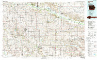
~ Grinnell IA topo map, 1:100000 scale, 30 X 60 Minute, Historical, 1984, updated 1989
Grinnell, Iowa, USGS topographic map dated 1984.
Includes geographic coordinates (latitude and longitude). This topographic map is suitable for hiking, camping, and exploring, or framing it as a wall map.
Printed on-demand using high resolution imagery, on heavy weight and acid free paper, or alternatively on a variety of synthetic materials.
Topos available on paper, Waterproof, Poly, or Tyvek. Usually shipping rolled, unless combined with other folded maps in one order.
- Product Number: USGS-5283675
- Free digital map download (high-resolution, GeoPDF): Grinnell, Iowa (file size: 23 MB)
- Map Size: please refer to the dimensions of the GeoPDF map above
- Weight (paper map): ca. 55 grams
- Map Type: POD USGS Topographic Map
- Map Series: HTMC
- Map Verison: Historical
- Cell ID: 67614
- Scan ID: 174768
- Imprint Year: 1989
- Woodland Tint: Yes
- Aerial Photo Year: 1983
- Edit Year: 1984
- Datum: NAD27
- Map Projection: Universal Transverse Mercator
- Map published by United States Geological Survey
- Map Language: English
- Scanner Resolution: 600 dpi
- Map Cell Name: Grinnell
- Grid size: 30 X 60 Minute
- Date on map: 1984
- Map Scale: 1:100000
- Geographical region: Iowa, United States
Neighboring Maps:
All neighboring USGS topo maps are available for sale online at a variety of scales.
Spatial coverage:
Topo map Grinnell, Iowa, covers the geographical area associated the following places:
- Carnforth - Irving - Searsboro - Arbor Lake Mobile Home Community - Timber Valley Mobile Home Park - Brooklyn - Stillwell - Grinnell - Haverhill - Potter - Ladora - Ambrose - Blairstown - Dayton - Wolf Lake Addition - Montour - Haven - Brownsville - Dunbar - Turner (historical) - Laurel - Millersburg - Lone Pine Mobile Home Court - Westfield - Victor - Ferguson - Montezuma - Murphy - Armah - Sully - Willows Mobile Home Court - Dillon - Helena - Luray - Malcom - Genoa Bluff - Dresden - Tilton - Long Point - Belle Plaine - Parnell - Guernsey - Hartwick - Toledo - Redman (historical) - Keystone - Gladstone - Luzerne - Newburg - Gilman - Sheridan - Tama - Arrowhead Mobile Home Park - Oakland Acres - Kellogg - Jacobs - Deep River - Chelsea - Vining - Pickering - Koszta - Lynnville - Barnes City - Williamsburg - Rushville - North English - Ewart - Killduff - Dover - Mesquakie Indian Settlement - Galesburg - Marengo - Holiday Lake - Taintor
- Map Area ID: AREA4241.5-93-92
- Northwest corner Lat/Long code: USGSNW42-93
- Northeast corner Lat/Long code: USGSNE42-92
- Southwest corner Lat/Long code: USGSSW41.5-93
- Southeast corner Lat/Long code: USGSSE41.5-92
- Northern map edge Latitude: 42
- Southern map edge Latitude: 41.5
- Western map edge Longitude: -93
- Eastern map edge Longitude: -92


