
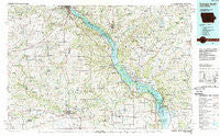
~ Dubuque South IA topo map, 1:100000 scale, 30 X 60 Minute, Historical, 1984, updated 1989
Dubuque South, Iowa, USGS topographic map dated 1984.
Includes geographic coordinates (latitude and longitude). This topographic map is suitable for hiking, camping, and exploring, or framing it as a wall map.
Printed on-demand using high resolution imagery, on heavy weight and acid free paper, or alternatively on a variety of synthetic materials.
Topos available on paper, Waterproof, Poly, or Tyvek. Usually shipping rolled, unless combined with other folded maps in one order.
- Product Number: USGS-5283663
- Free digital map download (high-resolution, GeoPDF): Dubuque South, Iowa (file size: 22 MB)
- Map Size: please refer to the dimensions of the GeoPDF map above
- Weight (paper map): ca. 55 grams
- Map Type: POD USGS Topographic Map
- Map Series: HTMC
- Map Verison: Historical
- Cell ID: 67440
- Scan ID: 174547
- Imprint Year: 1989
- Woodland Tint: Yes
- Aerial Photo Year: 1983
- Edit Year: 1984
- Datum: NAD27
- Map Projection: Universal Transverse Mercator
- Map published by United States Geological Survey
- Map Language: English
- Scanner Resolution: 600 dpi
- Map Cell Name: Dubuque South
- Grid size: 30 X 60 Minute
- Date on map: 1984
- Map Scale: 1:100000
- Geographical region: Iowa, United States
Neighboring Maps:
All neighboring USGS topo maps are available for sale online at a variety of scales.
Spatial coverage:
Topo map Dubuque South, Iowa, covers the geographical area associated the following places:
- Smiths - Sterling - Rice - Van Buren - Baldwin - Arnold - East Canton - Spragueville - Pleasant Creek - Miles - Green Island - Aiken - Emeline - Menominee - Samoa - Lost Canyon Mobile Home Park - Woodbine - Washington Mills - Zwingle - Epworth - Reeceville - Clay Mills - Pleasant Hill (historical) - Schapville - Hickory Grove - Blackhawk - Woodland Valley Courts - Bennettsville - South Garry Owen - Sabula - Nashville - Stockton - Brinksburg (historical) - Argo Fay - Ozark (historical) - Polsgrove - Country Air Mobile Home Estates - Cottonville - Shawondasse - J and J Mobile Home Park - Apple Canyon Lake - Center Grove - Twin Springs - Cattese - Maquoketa - Julien - West Iron Hills - Whitton - Springbrook - Table Mound Mobile Home Park - Griffiths Mobile Home Park - Lattnerville - La Motte - Browns - East Dubuque - Pleasant Valley - Bridgeport - Center Hill - Savanna - Bellevue - Fulton - Blanding - Portage - Millbrig (historical) - Galena Junction - Millville - Graf - Hanover - Monmouth - Ballyclough - Otter Creek - Lainsville - Weston (historical) - Buckhorn - Millrock - Preston - North Bellevue - Andrew - Hurstville - McGargels Ford - East Iron Hills - Wacker - Twin T Mobile Home Park - Gears Ferry - Fillmore - Bremen - Sweet Home (historical) - Peosta - Massey - Kidder - Burke - Teeds Grove - Rodden - Key West - Massbach - Guilford - Wilkins - Ace Mobile Home Park - Rockaway (historical) - Bernard
- Map Area ID: AREA42.542-91-90
- Northwest corner Lat/Long code: USGSNW42.5-91
- Northeast corner Lat/Long code: USGSNE42.5-90
- Southwest corner Lat/Long code: USGSSW42-91
- Southeast corner Lat/Long code: USGSSE42-90
- Northern map edge Latitude: 42.5
- Southern map edge Latitude: 42
- Western map edge Longitude: -91
- Eastern map edge Longitude: -90


