
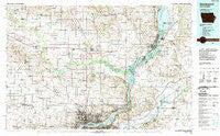
~ Davenport IA topo map, 1:100000 scale, 30 X 60 Minute, Historical, 1984, updated 1989
Davenport, Iowa, USGS topographic map dated 1984.
Includes geographic coordinates (latitude and longitude). This topographic map is suitable for hiking, camping, and exploring, or framing it as a wall map.
Printed on-demand using high resolution imagery, on heavy weight and acid free paper, or alternatively on a variety of synthetic materials.
Topos available on paper, Waterproof, Poly, or Tyvek. Usually shipping rolled, unless combined with other folded maps in one order.
- Product Number: USGS-5283651
- Free digital map download (high-resolution, GeoPDF): Davenport, Iowa (file size: 20 MB)
- Map Size: please refer to the dimensions of the GeoPDF map above
- Weight (paper map): ca. 55 grams
- Map Type: POD USGS Topographic Map
- Map Series: HTMC
- Map Verison: Historical
- Cell ID: 67384
- Scan ID: 174440
- Imprint Year: 1989
- Woodland Tint: Yes
- Aerial Photo Year: 1983
- Edit Year: 1984
- Datum: NAD27
- Map Projection: Universal Transverse Mercator
- Map published by United States Geological Survey
- Map Language: English
- Scanner Resolution: 600 dpi
- Map Cell Name: Davenport
- Grid size: 30 X 60 Minute
- Date on map: 1984
- Map Scale: 1:100000
- Geographical region: Iowa, United States
Neighboring Maps:
All neighboring USGS topo maps are available for sale online at a variety of scales.
Spatial coverage:
Topo map Davenport, Iowa, covers the geographical area associated the following places:
- Bennett - Moline - Grand Mound - Teds Mobile Home Park - Big Rock - Bliedorn - Rustic Ridge Mobile Home Park - Welton - Albany - Sibyl (historical) - Silvis - Walcott Eststes - Garden Plain - Osborn - Cleveland - Mount Joy - Oxford Junction - Plainview - Dixon - Maysville - Hickory Grove Mobile Home Park - Clinton Stock Yards - Noel (historical) - Goose Lake - Barstow - Walcott - Sikkemas Trailer Park - Rock Island - Rustic Acres - Hickory Grove - Blue Grass - De Witt - Hillsdale - Cedar Brook - Stockton - Devils Glen Mobile Home Court - New Liberty - Lakewood Park - Durant - Rivercrest Estates - Petersburg - Oliver - Green Acres - Probstei - Pleasant Valley - Ebner - Bryant - Fenton - Toronto - East Clinton - Mount Joy Mobile Home Park - Almont - Oxford Mills - Le Claire - North Welton - Black Hawk - Port Byron - Sherton Heights - Gambrill (historical) - Andover - Wheatland - Mineral Springs (historical) - Argo - Riverdale - Hometown Lakeside Mobile Home Park - Princeton - Great Oaks - Sunbury - Silver Creek Mobile Home Community - Glendale Mobile Home Park - Spring Valley - Ponderosa Park Mobile Home Park - Country Estates Mobile Home Park - Hampton - Bulgers Hollow - Shady Acres Mobile Home Park - Lost Nation - Carriage Place - Spring Hill - Shady Beach - Tenmile - Lowden - Chaney - Bettendorf - Fulton - Low Moor - Shaffton - Thomson - Union Grove - Panorama Park - Little Groves - New Dixon - Long Grove - Folletts - Cordova - Camanche - Erie - Babcock - Elvira - Davenport
- Map Area ID: AREA4241.5-91-90
- Northwest corner Lat/Long code: USGSNW42-91
- Northeast corner Lat/Long code: USGSNE42-90
- Southwest corner Lat/Long code: USGSSW41.5-91
- Southeast corner Lat/Long code: USGSSE41.5-90
- Northern map edge Latitude: 42
- Southern map edge Latitude: 41.5
- Western map edge Longitude: -91
- Eastern map edge Longitude: -90


