
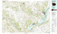
~ Burlington IA topo map, 1:100000 scale, 30 X 60 Minute, Historical, 1985, updated 1989
Burlington, Iowa, USGS topographic map dated 1985.
Includes geographic coordinates (latitude and longitude). This topographic map is suitable for hiking, camping, and exploring, or framing it as a wall map.
Printed on-demand using high resolution imagery, on heavy weight and acid free paper, or alternatively on a variety of synthetic materials.
Topos available on paper, Waterproof, Poly, or Tyvek. Usually shipping rolled, unless combined with other folded maps in one order.
- Product Number: USGS-5283635
- Free digital map download (high-resolution, GeoPDF): Burlington, Iowa (file size: 22 MB)
- Map Size: please refer to the dimensions of the GeoPDF map above
- Weight (paper map): ca. 55 grams
- Map Type: POD USGS Topographic Map
- Map Series: HTMC
- Map Verison: Historical
- Cell ID: 67202
- Scan ID: 174218
- Imprint Year: 1989
- Woodland Tint: Yes
- Aerial Photo Year: 1984
- Edit Year: 1985
- Datum: NAD27
- Map Projection: Universal Transverse Mercator
- Map published by United States Geological Survey
- Map Language: English
- Scanner Resolution: 600 dpi
- Map Cell Name: Burlington
- Grid size: 30 X 60 Minute
- Date on map: 1985
- Map Scale: 1:100000
- Geographical region: Iowa, United States
Neighboring Maps:
All neighboring USGS topo maps are available for sale online at a variety of scales.
Spatial coverage:
Topo map Burlington, Iowa, covers the geographical area associated the following places:
- Bluff Park - Utica - Danville - Kingston - Oakland Mills - Palestine (historical) - Parksville (historical) - Shokokon - Franklin - Carthage Lake - Jeffersonville (historical) - Lone Tree - Dallas City - Houghton - Sharon - Birmingham - La Crosse - Vernon - Danville Center - Old Niota - Mount Clare - New London - Lexington - Kemper - La Crew - Spring Grove - Pontoosuc - Disco - Nauvoo - Big Mound - Keteban Switch (historical) - Prospect Grove - Sawyer - Beaverdale - Viele - Augusta - Green Valley Mobile Home Court - West Point - Carman - Belfast (historical) - Mardan Mobile Home Court - Lockridge - Mount Zion - Aztec Mobile Home Park - Dodgeville - Niota - Argyle - Pierceville - Sperry - Patterson - Mount Pleasant - Bullard - Anson - Collett - Denmark - Saint Paul - Latty - Baltimore (historical) - Bricker - Winchester - Bonaparte - Denova - Congers Mobile Home Park - Echo Valley Mobile Home Park - Prairie Grove - Harrisburg - Iowa Junction - Donnellson - Durham - Pilot Grove - Adrian - Powellton - Scenic View Mobile Home Park - Bentonsport - Burnside - Middletown - Kline - Pleasant Grove - Lomax - Athens - Summit (historical) - Quashquema (historical) - Heapsville - Skunk River - Russellville (historical) - New Boston - South Augusta - Silver Lake (historical) - Burlington - Yellow Banks - Dumas - Wever - Farmington - Pleasant Hill (historical) - Lowell - Mount Sterling - Charleston - Galland - Plymouth - Countryside Mobile Home Court
- Map Area ID: AREA4140.5-92-91
- Northwest corner Lat/Long code: USGSNW41-92
- Northeast corner Lat/Long code: USGSNE41-91
- Southwest corner Lat/Long code: USGSSW40.5-92
- Southeast corner Lat/Long code: USGSSE40.5-91
- Northern map edge Latitude: 41
- Southern map edge Latitude: 40.5
- Western map edge Longitude: -92
- Eastern map edge Longitude: -91


