
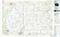
~ Ames IA topo map, 1:100000 scale, 30 X 60 Minute, Historical, 1985, updated 1985
Ames, Iowa, USGS topographic map dated 1985.
Includes geographic coordinates (latitude and longitude). This topographic map is suitable for hiking, camping, and exploring, or framing it as a wall map.
Printed on-demand using high resolution imagery, on heavy weight and acid free paper, or alternatively on a variety of synthetic materials.
Topos available on paper, Waterproof, Poly, or Tyvek. Usually shipping rolled, unless combined with other folded maps in one order.
- Product Number: USGS-5283625
- Free digital map download (high-resolution, GeoPDF): Ames, Iowa (file size: 13 MB)
- Map Size: please refer to the dimensions of the GeoPDF map above
- Weight (paper map): ca. 55 grams
- Map Type: POD USGS Topographic Map
- Map Series: HTMC
- Map Verison: Historical
- Cell ID: 67042
- Scan ID: 174061
- Imprint Year: 1985
- Woodland Tint: Yes
- Aerial Photo Year: 1983
- Edit Year: 1985
- Datum: NAD27
- Map Projection: Universal Transverse Mercator
- Planimetric: Yes
- Map published by United States Geological Survey
- Map Language: English
- Scanner Resolution: 600 dpi
- Map Cell Name: Ames
- Grid size: 30 X 60 Minute
- Date on map: 1985
- Map Scale: 1:100000
- Geographical region: Iowa, United States
Neighboring Maps:
All neighboring USGS topo maps are available for sale online at a variety of scales.
Spatial coverage:
Topo map Ames, Iowa, covers the geographical area associated the following places:
- Secor (historical) - Moningers - Hillcrest Mobile Home Park - Wilke - Garden City - Mackey - State Center - Ridgeport - Ericson - Racine - Remicker (historical) - Stonega - Country Aire Mobile Home Park - Bloomington - Story City - Ames - Boone - Blairsburg - Abbott - Berlin - Stratford - LaMoille - Whitten - Hubbard - Cleves - Lawn Hill - Highview - Griffen - Eldora - Zearing - McCallsburg - Saint Anthony - Buckeye - Illinois Grove - Bromley - Minerva - Rosedale - Jordan - Jewell - Hughs - Liscomb - Moingona - Homer - Shady Grove Mobile Home Park - Homestead Colony - Radcliffe - Centerville - Marietta - Gifford - Clemons - Owasa - Meadow Lane Mobile Home Park - Xenia - Duncombe - Eagle City - Colo - Union - Crestview Mobile Home Park - Roland - Zenorsville - Rough Woods Hill - Ellsworth - Coal Valley - Logansport - Gilbert - Abbott Crossing (historical) - Williams - Fernald - Flugstad (historical) - Ontario - Stanhope - Old Orchard Mobile Home Park - Steamboat Rock - Webster City - Nevada - Sherman - New Providence - Fraser - Kamrar - Randall - Bangor
- Map Area ID: AREA42.542-94-93
- Northwest corner Lat/Long code: USGSNW42.5-94
- Northeast corner Lat/Long code: USGSNE42.5-93
- Southwest corner Lat/Long code: USGSSW42-94
- Southeast corner Lat/Long code: USGSSE42-93
- Northern map edge Latitude: 42.5
- Southern map edge Latitude: 42
- Western map edge Longitude: -94
- Eastern map edge Longitude: -93


