
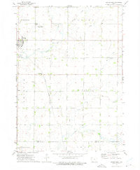
~ George East IA topo map, 1:24000 scale, 7.5 X 7.5 Minute, Historical, 1972, updated 1975
George East, Iowa, USGS topographic map dated 1972.
Includes geographic coordinates (latitude and longitude). This topographic map is suitable for hiking, camping, and exploring, or framing it as a wall map.
Printed on-demand using high resolution imagery, on heavy weight and acid free paper, or alternatively on a variety of synthetic materials.
Topos available on paper, Waterproof, Poly, or Tyvek. Usually shipping rolled, unless combined with other folded maps in one order.
- Product Number: USGS-5281637
- Free digital map download (high-resolution, GeoPDF): George East, Iowa (file size: 6 MB)
- Map Size: please refer to the dimensions of the GeoPDF map above
- Weight (paper map): ca. 55 grams
- Map Type: POD USGS Topographic Map
- Map Series: HTMC
- Map Verison: Historical
- Cell ID: 17066
- Scan ID: 174709
- Imprint Year: 1975
- Woodland Tint: Yes
- Aerial Photo Year: 1972
- Field Check Year: 1972
- Datum: NAD27
- Map Projection: Lambert Conformal Conic
- Map published by United States Geological Survey
- Map Language: English
- Scanner Resolution: 600 dpi
- Map Cell Name: George East
- Grid size: 7.5 X 7.5 Minute
- Date on map: 1972
- Map Scale: 1:24000
- Geographical region: Iowa, United States
Neighboring Maps:
All neighboring USGS topo maps are available for sale online at a variety of scales.
Spatial coverage:
Topo map George East, Iowa, covers the geographical area associated the following places:
- George - Little Rock High School - First Baptist Church - George Emergency Medical Services - Ebenezer Presbyterian Church - George Community Good Samaritan Hospital - George Fire Department - Schrick Farms - Township of Dale - De Groot Farms - Lyon County First Presbyterian Church Cemetery - George Elementary School - Zoar Presbyterian Church Cemetery - Little Rock River Wildlife Area - Central Unit - Zoar Church - Dream Street Farms - First Presbyterian Church - Immanuel Lutheran Church - Zion Cemetery - Sudenga Industries Landing Field (historical) - Dale Townhall - L and E Farms - Tabernacle Baptist Church - Whitney Creek - Grant Townhall - Zoar Creek - West Rat Creek - Rat Creek
- Map Area ID: AREA43.37543.25-96-95.875
- Northwest corner Lat/Long code: USGSNW43.375-96
- Northeast corner Lat/Long code: USGSNE43.375-95.875
- Southwest corner Lat/Long code: USGSSW43.25-96
- Southeast corner Lat/Long code: USGSSE43.25-95.875
- Northern map edge Latitude: 43.375
- Southern map edge Latitude: 43.25
- Western map edge Longitude: -96
- Eastern map edge Longitude: -95.875


