
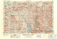
~ Manhattan KS topo map, 1:250000 scale, 1 X 2 Degree, Historical, 1955, updated 1973
Manhattan, Kansas, USGS topographic map dated 1955.
Includes geographic coordinates (latitude and longitude). This topographic map is suitable for hiking, camping, and exploring, or framing it as a wall map.
Printed on-demand using high resolution imagery, on heavy weight and acid free paper, or alternatively on a variety of synthetic materials.
Topos available on paper, Waterproof, Poly, or Tyvek. Usually shipping rolled, unless combined with other folded maps in one order.
- Product Number: USGS-5278162
- Free digital map download (high-resolution, GeoPDF): Manhattan, Kansas (file size: 15 MB)
- Map Size: please refer to the dimensions of the GeoPDF map above
- Weight (paper map): ca. 55 grams
- Map Type: POD USGS Topographic Map
- Map Series: HTMC
- Map Verison: Historical
- Cell ID: 72237
- Scan ID: 707459
- Imprint Year: 1973
- Woodland Tint: Yes
- Aerial Photo Year: 1954
- Edit Year: 1969
- Datum: NAD27
- Map Projection: Transverse Mercator
- Map published by United States Geological Survey
- Map published by: Military, Other
- Map Language: English
- Scanner Resolution: 508 dpi
- Map Cell Name: Manhattan
- Grid size: 1 X 2 Degree
- Date on map: 1955
- Map Scale: 1:250000
- Geographical region: Kansas, United States
Neighboring Maps:
All neighboring USGS topo maps are available for sale online at a variety of scales.
Spatial coverage:
Topo map Manhattan, Kansas, covers the geographical area associated the following places:
- Alcove Spring - Lindsey - Summerfield - Cuba - Northwind Mobile Home Park - Tabor - Harbine - Grandview Plaza - Sullivan - Saint Benedict - Haddam - Lovewell - Black Squirrel Mobile Home Park - Home - Republic - Mobile Villa Trailer Court - Lakeside Mobile Home Court - Ladysmith - Blue Valley Mobile Home Park - Washington - Wakefield - Simpson - Ames - Clay Center - White Rock - Ada - Bennington - Hawks Landing Mobile Home Park - Minneapolis - Barret - Hanover - Barnes - Eureka Lake - Oak Hill - Cottonwood Mobile Home Estates - Saint George Mobile Home Park - Idana - Manhattan - Vine Creek - Waterville - Junction City Regency Mobile Home Park - Bretz's Mobile Home Park - Rocky Ford - Morganville - Agenda - J and L Mobile Home Park - Huscher - Keats - Macyville - Double J Mobile Home Park - Hollenberg - Rydal - America City - Riverchase Mobile Home Park - Belvue - Morrowville - Aikins - Jamestown - Saint George - Maple Hill - Beverly - In the Field Mobile Home Park - Browndale - Alma - Lone Elm - Blaine - Milford - Aurora - Saint Joseph - Wells - Randolph - Palmer - Keating Mobile Home Park - Talmo - Vliets - Beattie - Summit - Sunset Park - Hermansberg - Sherdahl - Kimeo - Lewis Mobile Home Park - Country Gardens Mobile Home Park - Buckeye - Formoso - Rocky Ford Mobile Home Park - Enosdale - Norway - Alida - Coursens Grove (historical) - Sutphen - Narka - Calderhead - Wayne - Riley - Marietta - Pillsbury Crossing - Miller Mobile Home Court - Yuma - Oketo
- Map Area ID: AREA4039-98-96
- Northwest corner Lat/Long code: USGSNW40-98
- Northeast corner Lat/Long code: USGSNE40-96
- Southwest corner Lat/Long code: USGSSW39-98
- Southeast corner Lat/Long code: USGSSE39-96
- Northern map edge Latitude: 40
- Southern map edge Latitude: 39
- Western map edge Longitude: -98
- Eastern map edge Longitude: -96


