
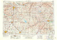
~ Hutchinson KS topo map, 1:250000 scale, 1 X 2 Degree, Historical, 1955, updated 1973
Hutchinson, Kansas, USGS topographic map dated 1955.
Includes geographic coordinates (latitude and longitude). This topographic map is suitable for hiking, camping, and exploring, or framing it as a wall map.
Printed on-demand using high resolution imagery, on heavy weight and acid free paper, or alternatively on a variety of synthetic materials.
Topos available on paper, Waterproof, Poly, or Tyvek. Usually shipping rolled, unless combined with other folded maps in one order.
- Product Number: USGS-5278146
- Free digital map download (high-resolution, GeoPDF): Hutchinson, Kansas (file size: 13 MB)
- Map Size: please refer to the dimensions of the GeoPDF map above
- Weight (paper map): ca. 55 grams
- Map Type: POD USGS Topographic Map
- Map Series: HTMC
- Map Verison: Historical
- Cell ID: 72229
- Scan ID: 707406
- Imprint Year: 1973
- Woodland Tint: Yes
- Aerial Photo Year: 1954
- Edit Year: 1969
- Field Check Year: 1955
- Datum: Unstated
- Map Projection: Transverse Mercator
- Map published by United States Geological Survey
- Map Language: English
- Scanner Resolution: 508 dpi
- Map Cell Name: Hutchinson
- Grid size: 1 X 2 Degree
- Date on map: 1955
- Map Scale: 1:250000
- Geographical region: Kansas, United States
Neighboring Maps:
All neighboring USGS topo maps are available for sale online at a variety of scales.
Spatial coverage:
Topo map Hutchinson, Kansas, covers the geographical area associated the following places:
- McPherson - Verdi - Belmont Mobile Home Estates - Kipp - Lang - Salemsborg - Galva - Helmick - Olpe - Navarre - Conway - Gladstone - Clements - Koepke Mobile Manor - Kelso - Glendale - Punkin Center - Lincoln Mobile Home Village - Kanopolis Lake Park - Admire - Moundridge - Juniata - Pearl - Rockland - New Cambria - New Gottland - Allendorph - Prairie Village Mobile Home Park - Keene - John's Mobile Home Park - Hessdale - Ramona - Dwight - Florence - Americus - Halstead - Burns - Lost Springs - Cassoday - Southgate Mobile Home Park - Madison - Jenkins - Alta Mills - Mackie - Trenton - Hymer - Merrick - Bazaar - Falun - Matfield Green - Bridgeport - Delavan - Mentor - Strong City - Showalter Mobile Home Park - Dunlap - Carlton - Parkerville - Kansas Falls - M and M Mobile Home Court - Lehigh - Luther Ralph Mobile Home Park - Prairie Estates Mobile Home Park - Herington - Melody Acres Mobile Home Park - Lyona - Hillsboro - Hutchinson - Rishel - Wonsevu - Golden Spur Mobile Home Park - Bradford - Langley - Shamrock Mobile Home Estates - White City - Phillips Village (historical) - Hilton - McGraw - Oursler - Zimmerdale - Willowbrook - Skiddy - Allen - Cottonwood Mobile Home Park - Aulne - Smokey Valley Mobile Home Park - Western Community Park - Arcola - Kenbro - Goessel - Pilsen - Acme - Shipton - Burkett - Hope - Westhill Mobile Home Park - Durham - Toledo - Jacobs - Eastshore
- Map Area ID: AREA3938-98-96
- Northwest corner Lat/Long code: USGSNW39-98
- Northeast corner Lat/Long code: USGSNE39-96
- Southwest corner Lat/Long code: USGSSW38-98
- Southeast corner Lat/Long code: USGSSE38-96
- Northern map edge Latitude: 39
- Southern map edge Latitude: 38
- Western map edge Longitude: -98
- Eastern map edge Longitude: -96


