
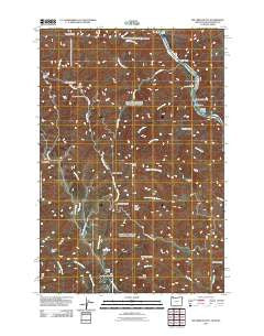
~ Jim Creek Butte OR topo map, 1:24000 scale, 7.5 X 7.5 Minute, Historical, 2011
Jim Creek Butte, Oregon, USGS topographic map dated 2011.
Includes geographic coordinates (latitude and longitude). This topographic map is suitable for hiking, camping, and exploring, or framing it as a wall map.
Printed on-demand using high resolution imagery, on heavy weight and acid free paper, or alternatively on a variety of synthetic materials.
Topos available on paper, Waterproof, Poly, or Tyvek. Usually shipping rolled, unless combined with other folded maps in one order.
- Product Number: USGS-5271330
- Free digital map download (high-resolution, GeoPDF): Jim Creek Butte, Oregon (file size: 16 MB)
- Map Size: please refer to the dimensions of the GeoPDF map above
- Weight (paper map): ca. 55 grams
- Map Type: POD USGS Topographic Map
- Map Series: US Topo
- Map Verison: Historical
- Cell ID: 22618
- Datum: North American Datum of 1983
- Map Projection: Transverse Mercator
- Map Cell Name: Jim Creek Butte
- Grid size: 7.5 X 7.5 Minute
- Date on map: 2011
- Map Scale: 1:24000
- Geographical region: Oregon, United States
Neighboring Maps:
All neighboring USGS topo maps are available for sale online at a variety of scales.
Spatial coverage:
Topo map Jim Creek Butte, Oregon, covers the geographical area associated the following places:
- Deadhorse Creek - Big Cougar Creek - Cold Spring Ridge - Lent Butte - South Fork Jim Creek - Spencer Creek - Cold Spring - Upper Cochran Rapids - Little Cougar Creek - Cave Gulch - China Garden Creek - State Line Creek - Garden Creek - Gailord Gulch - Jim Creek Ranch - Fir Tree Canyon - Frog Pond Butte - Downey Gulch - Dry Creek Ridge - Coon Hollow - Lower Cache Creek Rapids - North Fork Jim Creek - Frog Pond - Jack Lowery Creek - Chaffer Canyon - Cabin Creek - Mount Wilson - Cochran Rapids - China Garden - Downey Saddle - Jim Creek Butte - Jenny Corral Gulch - Cougar Rapids Bar - Cougar Rapids - Baldwin Area - Road Gulch - Lower Cochran Rapids - Coon Creek - Lower Cache Creek Rapids - Cache Creek Ranch Recreation Site - Old Cold Spring - Upper Cache Creek Rapids - Smooth Gulch - Dry Creek - McDuff Rapids - Cold Spring Creek - Cochran Islands - Sheldon Creek - Cold Spring Cow Camp - Cache Creek
- Map Area ID: AREA4645.875-117-116.875
- Northwest corner Lat/Long code: USGSNW46-117
- Northeast corner Lat/Long code: USGSNE46-116.875
- Southwest corner Lat/Long code: USGSSW45.875-117
- Southeast corner Lat/Long code: USGSSE45.875-116.875
- Northern map edge Latitude: 46
- Southern map edge Latitude: 45.875
- Western map edge Longitude: -117
- Eastern map edge Longitude: -116.875


