
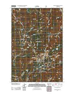
~ Three Brothers MT topo map, 1:24000 scale, 7.5 X 7.5 Minute, Historical, 2011
Three Brothers, Montana, USGS topographic map dated 2011.
Includes geographic coordinates (latitude and longitude). This topographic map is suitable for hiking, camping, and exploring, or framing it as a wall map.
Printed on-demand using high resolution imagery, on heavy weight and acid free paper, or alternatively on a variety of synthetic materials.
Topos available on paper, Waterproof, Poly, or Tyvek. Usually shipping rolled, unless combined with other folded maps in one order.
- Product Number: USGS-5270910
- Free digital map download (high-resolution, GeoPDF): Three Brothers, Montana (file size: 23 MB)
- Map Size: please refer to the dimensions of the GeoPDF map above
- Weight (paper map): ca. 55 grams
- Map Type: POD USGS Topographic Map
- Map Series: US Topo
- Map Verison: Historical
- Cell ID: 44992
- Datum: North American Datum of 1983
- Map Projection: Transverse Mercator
- Map Cell Name: Three Brothers
- Grid size: 7.5 X 7.5 Minute
- Date on map: 2011
- Map Scale: 1:24000
- Geographical region: Montana, United States
Neighboring Maps:
All neighboring USGS topo maps are available for sale online at a variety of scales.
Spatial coverage:
Topo map Three Brothers, Montana, covers the geographical area associated the following places:
- Flume Gulch - Solar Mine - Buckeye Mine - Cataract Meadows - Booth Gulch - Porphyry Dike Mine - Monte Cristo Mine - Bullion Mine - 19 Hundred - Spring Creek - Paupers Dream Mine - Jimmy - Ontario Millsite - Clear Creek - Pocahontas - O'Keefe Mountain - Ruby Creek - Sally Ann Creek - Ontario (historical) - NW NE Section 27 Mine - Old Baldy Mountain - Jericho Creek - Close Shave - Anna R/Hattie M Mine - O'Keefe Creek - Woodrow Wilson - Molly Snow Mine - May Lillie Mine - West Ontario Mine - Clemmer Gulch - Perry Parks Placer Mine - Champion Mine - Beattrice Mine - Hub Camp Mine - SE SE Section 13 - Ontario Post Office (historical) - Banner Creek - Travis Reservoir - May-Lillie Mine - SE SE Section 15 Mine - Daniel Stanton - Sure Thing Swamps - Lily-Orphan Boy Mine - Dorothy Snow Mine - SW SE Section 5 - Lucky Joe - Bryan Creek - SW NW Section 26 Mine - Lee Mountain (historical) - Armstrong Mine - Newmans Camp - Rocker/Ada Mine - Hub Camp - Jericho Mountain - SW NW Section 7 Mine - Elk Gulch - Bison Creek - NW NW Section 13 - Sure Thing Mine - Solar Mine - Blue Boy - Placer - Ontario Mine - Justice Mine - Hard Luck Mine - Monte Cristo Mine - Lady Nell/Ada Mine - Bullion Parks - Placer Mine - Scott Reservoir - Peter - Lily/Orphan Boy Mine - Home Stake Mine - NW SW Section 15 Mine - Lee Mountain - Hard Luck Mine - Scott Reservoir Dam - Telegraph Mine - May Day - Josephine Mine - Dan-Kim - SE NW Section 30 Mine - SW SE Section 10 Mine - NE NW Section 6 Mine - Grub Gulch - Three Brothers - Buckeye Mine - Jimmys Creek - Lady Hennessy Mine - NE NW Section 23 - Perry Parks Mine - SE SE Section 35 Mine - Sure Thing Mine - Luttrell Peak - Monitor Creek - Moose Gulch - Excelsior Mine - Beatrice
- Map Area ID: AREA46.546.375-112.375-112.25
- Northwest corner Lat/Long code: USGSNW46.5-112.375
- Northeast corner Lat/Long code: USGSNE46.5-112.25
- Southwest corner Lat/Long code: USGSSW46.375-112.375
- Southeast corner Lat/Long code: USGSSE46.375-112.25
- Northern map edge Latitude: 46.5
- Southern map edge Latitude: 46.375
- Western map edge Longitude: -112.375
- Eastern map edge Longitude: -112.25


