
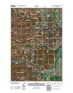
~ Big Hole Battlefield MT topo map, 1:24000 scale, 7.5 X 7.5 Minute, Historical, 2011
Big Hole Battlefield, Montana, USGS topographic map dated 2011.
Includes geographic coordinates (latitude and longitude). This topographic map is suitable for hiking, camping, and exploring, or framing it as a wall map.
Printed on-demand using high resolution imagery, on heavy weight and acid free paper, or alternatively on a variety of synthetic materials.
Topos available on paper, Waterproof, Poly, or Tyvek. Usually shipping rolled, unless combined with other folded maps in one order.
- Product Number: USGS-5266988
- Free digital map download (high-resolution, GeoPDF): Big Hole Battlefield, Montana (file size: 20 MB)
- Map Size: please refer to the dimensions of the GeoPDF map above
- Weight (paper map): ca. 55 grams
- Map Type: POD USGS Topographic Map
- Map Series: US Topo
- Map Verison: Historical
- Cell ID: 69342
- Datum: North American Datum of 1983
- Map Projection: Transverse Mercator
- Map Cell Name: Big Hole Battlefield
- Grid size: 7.5 X 7.5 Minute
- Date on map: 2011
- Map Scale: 1:24000
- Geographical region: Montana, United States
Neighboring Maps:
All neighboring USGS topo maps are available for sale online at a variety of scales.
Spatial coverage:
Topo map Big Hole Battlefield, Montana, covers the geographical area associated the following places:
- Big Hole National Battlefield - 02S17W09ABAD01 Spring - Maybee Meadows - 02S17W26BBBB01 Well - Salix Creek - Monumental City (historical) - Wooster Mountain - Trail Creek - Battle Mountain - Beaver Pond Basin - Ruby Creek - 02S17W16ACAB01 Spring - Runaway Creek - Placer Creek - Beaver Creek - Big Hole National Battlefield Visitor Center - 02S17W24DCAA01 Well - Maybee Ranch - Bender Creek - Addition Creek - Cascade Creek - Sage Creek - South Fork Tie Creek - Nymphaea Lake - 02S17W25CADA01 Well
- Map Area ID: AREA45.7545.625-113.75-113.625
- Northwest corner Lat/Long code: USGSNW45.75-113.75
- Northeast corner Lat/Long code: USGSNE45.75-113.625
- Southwest corner Lat/Long code: USGSSW45.625-113.75
- Southeast corner Lat/Long code: USGSSE45.625-113.625
- Northern map edge Latitude: 45.75
- Southern map edge Latitude: 45.625
- Western map edge Longitude: -113.75
- Eastern map edge Longitude: -113.625


