
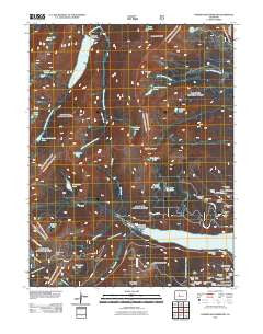
~ Homestake Reservoir CO topo map, 1:24000 scale, 7.5 X 7.5 Minute, Historical, 2011
Homestake Reservoir, Colorado, USGS topographic map dated 2011.
Includes geographic coordinates (latitude and longitude). This topographic map is suitable for hiking, camping, and exploring, or framing it as a wall map.
Printed on-demand using high resolution imagery, on heavy weight and acid free paper, or alternatively on a variety of synthetic materials.
Topos available on paper, Waterproof, Poly, or Tyvek. Usually shipping rolled, unless combined with other folded maps in one order.
- Product Number: USGS-5258395
- Free digital map download (high-resolution, GeoPDF): Homestake Reservoir, Colorado (file size: 29 MB)
- Map Size: please refer to the dimensions of the GeoPDF map above
- Weight (paper map): ca. 55 grams
- Map Type: POD USGS Topographic Map
- Map Series: US Topo
- Map Verison: Historical
- Cell ID: 20857
- Datum: North American Datum of 1983
- Map Projection: Transverse Mercator
- Map Cell Name: Homestake Reservoir
- Grid size: 7.5 X 7.5 Minute
- Date on map: 2011
- Map Scale: 1:24000
- Geographical region: Colorado, United States
Neighboring Maps:
All neighboring USGS topo maps are available for sale online at a variety of scales.
Spatial coverage:
Topo map Homestake Reservoir, Colorado, covers the geographical area associated the following places:
- Bear Lake - Rosse Tunnel - Bartlett Gulch - Swisher Tunnel Mine - Lonesome Lake - Bench Lakes - Glacier Creek - Golden Curry Mine - Buffalo Park - Dinero Tunnel - Timberline Lake - Hagerman Lake - Poor Boy Mine - Homestake Tunnel - Lake Esther - Hagerman Pass - Galena Lake - Middle Fork Homestake Creek - Tiger Tunnel - Sugarloaf Gulch - Bald Eagle Mountain - Griffin Tunnels - Sugarloaf Mountain - Deckers Lake - Little Sugarloaf Gulch - Nelson Tunnel - Iron Mask Mine - West Tennessee Lakes - Boyd Tunnel Mine - Shingle Mill Gulch - East Fork Homestake Creek - Homestake Mine - Isolation Lakes - South Portal Outlet - Upper Homestake Lake - Tiger Shaft - Busk Creek - Wilkes Barre Tunnels - Main Range Trail - Bartlett Shaft - Grandview Shaft - Little Annie Mine - Bear Creek - Virginia Lake - Saint Kevin Lake - Slide Lake - Paradise Lakes - Hagerman Tunnel - Homestake Project Dam - Little Sugar Loaf Placer Mine - Turquoise Lake - Saint Kevin Shaft - Homestake Reservoir - Galena Mountain - Shields Mine - Bartlett Tunnel - Mill Creek - Turquoise Chief Mine - Homestake Peak - Charles H Boustead Tunnel - Ivanhoe Tunnel - Mary Queen Campground
- Map Area ID: AREA39.37539.25-106.5-106.375
- Northwest corner Lat/Long code: USGSNW39.375-106.5
- Northeast corner Lat/Long code: USGSNE39.375-106.375
- Southwest corner Lat/Long code: USGSSW39.25-106.5
- Southeast corner Lat/Long code: USGSSE39.25-106.375
- Northern map edge Latitude: 39.375
- Southern map edge Latitude: 39.25
- Western map edge Longitude: -106.5
- Eastern map edge Longitude: -106.375


