
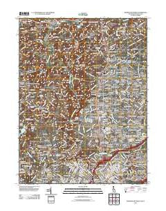
~ Wilmington North DE topo map, 1:24000 scale, 7.5 X 7.5 Minute, Historical, 2011
Wilmington North, Delaware, USGS topographic map dated 2011.
Includes geographic coordinates (latitude and longitude). This topographic map is suitable for hiking, camping, and exploring, or framing it as a wall map.
Printed on-demand using high resolution imagery, on heavy weight and acid free paper, or alternatively on a variety of synthetic materials.
Topos available on paper, Waterproof, Poly, or Tyvek. Usually shipping rolled, unless combined with other folded maps in one order.
- Product Number: USGS-5257327
- Free digital map download (high-resolution, GeoPDF): Wilmington North, Delaware (file size: 23 MB)
- Map Size: please refer to the dimensions of the GeoPDF map above
- Weight (paper map): ca. 55 grams
- Map Type: POD USGS Topographic Map
- Map Series: US Topo
- Map Verison: Historical
- Cell ID: 49297
- Datum: North American Datum of 1983
- Map Projection: Transverse Mercator
- Map Cell Name: Wilmington North
- Grid size: 7.5 X 7.5 Minute
- Date on map: 2011
- Map Scale: 1:24000
- Geographical region: Delaware, United States
Neighboring Maps:
All neighboring USGS topo maps are available for sale online at a variety of scales.
Spatial coverage:
Topo map Wilmington North, Delaware, covers the geographical area associated the following places:
- Phillips Heights - Calais Woods - Alapocas - High Point - Barkley - Tavistock - Shipley Woods - Colonial Woods - Devonshire - Concord Hills - Ridgewood - Talleyville - Silverbrook - Chadds Ford - Brandywine Hills - Chadds Ford Junction - Carrcroft Crest - Rockwood Woods - Clifton Park Manor - Henry Clay - Hillcrest - Marrow Tract - Club Lane - Rockland - Brandywine Perry Park - Brandywine Summit - Monroe Park - Weldin Woods - Woodbrook - Birch Knoll - Greenville - Weldin Farms - Westbrite - Beau Tree - Brandywine - Naamans Manor - Elam - Rock Manor - Woodbine - Twin Oaks - Penny Acres - Forest Hills Park - Holiday Hills - Oak Lane Manor - Deerhurst - Smithfield Estates - Delwynn - North Chase - Westwood Manor - Brandywood - Pennington - Bellefonte - Carrcroft - Bellewood - Wickwood - Sedgley Farms - Blue Ball - Fairfax - Guyencourt - Concord Manor - Gumwood - Cossart - Brandywine Commons - Pierson Farms - The Ridings of Chadds Ford - Gristmill Woods - Fairfax Farms - Shipley Heights - Chapelcrest - Barley Woods - Greenville Place - Normandy Manor - Galewood - Stonehaven - Weber Tract - Dartmouth Woods II - Edgemoor Terrace - Windsor Hills - Sharpley - Talleys Corner - Webster Farm - Augustine - Mayfield - Delaware Heights - Shipley Chase - Concord Crossing - Deerbrook I - Green Meadow - Williamhurst - Surrey Park - Village of Rocky Run - Chalfonte - Deerbrook II - Johnsons Corner - Pennyhill - Chadds Ford Knoll - Wynnewood - Norway - Greenville Development - Wynleigh
- Map Area ID: AREA39.87539.75-75.625-75.5
- Northwest corner Lat/Long code: USGSNW39.875-75.625
- Northeast corner Lat/Long code: USGSNE39.875-75.5
- Southwest corner Lat/Long code: USGSSW39.75-75.625
- Southeast corner Lat/Long code: USGSSE39.75-75.5
- Northern map edge Latitude: 39.875
- Southern map edge Latitude: 39.75
- Western map edge Longitude: -75.625
- Eastern map edge Longitude: -75.5


