
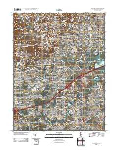
~ Newark East DE topo map, 1:24000 scale, 7.5 X 7.5 Minute, Historical, 2011
Newark East, Delaware, USGS topographic map dated 2011.
Includes geographic coordinates (latitude and longitude). This topographic map is suitable for hiking, camping, and exploring, or framing it as a wall map.
Printed on-demand using high resolution imagery, on heavy weight and acid free paper, or alternatively on a variety of synthetic materials.
Topos available on paper, Waterproof, Poly, or Tyvek. Usually shipping rolled, unless combined with other folded maps in one order.
- Product Number: USGS-5257321
- Free digital map download (high-resolution, GeoPDF): Newark East, Delaware (file size: 23 MB)
- Map Size: please refer to the dimensions of the GeoPDF map above
- Weight (paper map): ca. 55 grams
- Map Type: POD USGS Topographic Map
- Map Series: US Topo
- Map Verison: Historical
- Cell ID: 31899
- Datum: North American Datum of 1983
- Map Projection: Transverse Mercator
- Map Cell Name: Newark East
- Grid size: 7.5 X 7.5 Minute
- Date on map: 2011
- Map Scale: 1:24000
- Geographical region: Delaware, United States
Neighboring Maps:
All neighboring USGS topo maps are available for sale online at a variety of scales.
Spatial coverage:
Topo map Newark East, Delaware, covers the geographical area associated the following places:
- Delpark Manor - Windy Mill Park - Wilson - Christiana Green - Red Mills Farms - Smith Mill Farms - Rolling Hills - Capital Trail Farms - Timber Ridge - Iron Hills Apartments - Faulkland Heights - Sycamore Gardens - Heather Woods - Arbor Pointe Apartments - The Elms - Faulkland - Pike Creek - Hyde Park - Oakdale - Linden Heath - Lumbrook - Kiamensi Heights - Brandywine Springs - Melanie - Chestnut Hill Estates - Pendrew Manor - Varlano - Pigeon Run - Plum Run - Glenville - Pencader - Brookhaven - Pike Creek Valley - Marydale - Wood Mill - Ruthby - Brookbend - Bear - Roseville Park - Marshallton Green - Rivers End - Whilton - Pennock - Albertson - Ivy Ridge - Stratford - Wellington Woods - Salem Woods - Drummond Ridge - Skyline Crest - Corner Ketch - Henderson Heights - Greenbridge - Eastburn Heights - Greenbridge - Glen Berne Estates - Duncan Glen - Cherokee Woods - Newark - Albion - Kiamensi Gardens - Village of Cantebury - Princeton Wood II - Carriage Run - Pleasantville - Milford Meadows - Stones Throw - Catalina Gardens - Mermaid Run - Todd Estates - Choate - Stanton Estates - Woodshade - Windy Hills - Delaplane Manor - Kirkwood Gardens - Harmony Hills - Brookside - Eastburn Farms - Rutherford - Victoria Woods - Tybrook - The Highlands - Albertson Park - Milltown - Monterey Farms - Coach Hill - Westfield - The Bluffs - Greenbank - The Villa - English Village - The Hills of Skyline - Yorkshire - Drummond North - Newark Oaks - Raintree Village - Fairway Falls - Cedars - Elmwood
- Map Area ID: AREA39.7539.625-75.75-75.625
- Northwest corner Lat/Long code: USGSNW39.75-75.75
- Northeast corner Lat/Long code: USGSNE39.75-75.625
- Southwest corner Lat/Long code: USGSSW39.625-75.75
- Southeast corner Lat/Long code: USGSSE39.625-75.625
- Northern map edge Latitude: 39.75
- Southern map edge Latitude: 39.625
- Western map edge Longitude: -75.75
- Eastern map edge Longitude: -75.625


