
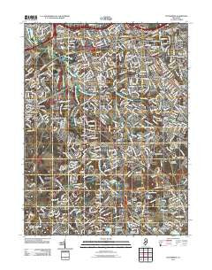
~ Runnemede NJ topo map, 1:24000 scale, 7.5 X 7.5 Minute, Historical, 2011
Runnemede, New Jersey, USGS topographic map dated 2011.
Includes geographic coordinates (latitude and longitude). This topographic map is suitable for hiking, camping, and exploring, or framing it as a wall map.
Printed on-demand using high resolution imagery, on heavy weight and acid free paper, or alternatively on a variety of synthetic materials.
Topos available on paper, Waterproof, Poly, or Tyvek. Usually shipping rolled, unless combined with other folded maps in one order.
- Product Number: USGS-5257297
- Free digital map download (high-resolution, GeoPDF): Runnemede, New Jersey (file size: 31 MB)
- Map Size: please refer to the dimensions of the GeoPDF map above
- Weight (paper map): ca. 55 grams
- Map Type: POD USGS Topographic Map
- Map Series: US Topo
- Map Verison: Historical
- Cell ID: 38931
- Datum: North American Datum of 1983
- Map Projection: Transverse Mercator
- Map Cell Name: Runnemede
- Grid size: 7.5 X 7.5 Minute
- Date on map: 2011
- Map Scale: 1:24000
- Geographical region: New Jersey, United States
Neighboring Maps:
All neighboring USGS topo maps are available for sale online at a variety of scales.
Spatial coverage:
Topo map Runnemede, New Jersey, covers the geographical area associated the following places:
- Blenheim - Hilltop - Millbridge - Brooklawn - Magnolia - Westville Grove - Greenland - Village of Glen Oaks - Creesville - Lawnside - Osage - Erial - Green Tree - Gardenville - Ashland - Garden City - Clements Bridge - Hi-Nella - Stratford - Westcotville - Downs Farms - Fairview - Runnemede - Grenloch - Barrington - Snow Hill - Brownsville - Bishop Wood - Sunset Beach - Gardenville Center - Salina - Lakeland - Turnersville - Cherrywood - Laurel Springs - Bellmawr - Davisville - Lambs Terrace - Chews - Hurffville - Bells Lake - Good Intent - Somerdale - Cooper Village - Hickstown - Blackwood - Terrestria - Glendora - Blackwood Terrace - Mechanicsville - Almonesson - Revere Run - Grenloch Terrace - Prossers Mills
- Map Area ID: AREA39.87539.75-75.125-75
- Northwest corner Lat/Long code: USGSNW39.875-75.125
- Northeast corner Lat/Long code: USGSNE39.875-75
- Southwest corner Lat/Long code: USGSSW39.75-75.125
- Southeast corner Lat/Long code: USGSSE39.75-75
- Northern map edge Latitude: 39.875
- Southern map edge Latitude: 39.75
- Western map edge Longitude: -75.125
- Eastern map edge Longitude: -75


