
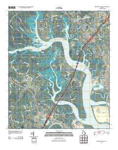
~ Brunswick West GA topo map, 1:24000 scale, 7.5 X 7.5 Minute, Historical, 2011
Brunswick West, Georgia, USGS topographic map dated 2011.
Includes geographic coordinates (latitude and longitude). This topographic map is suitable for hiking, camping, and exploring, or framing it as a wall map.
Printed on-demand using high resolution imagery, on heavy weight and acid free paper, or alternatively on a variety of synthetic materials.
Topos available on paper, Waterproof, Poly, or Tyvek. Usually shipping rolled, unless combined with other folded maps in one order.
- Product Number: USGS-5250177
- Free digital map download (high-resolution, GeoPDF): Brunswick West, Georgia (file size: 17 MB)
- Map Size: please refer to the dimensions of the GeoPDF map above
- Weight (paper map): ca. 55 grams
- Map Type: POD USGS Topographic Map
- Map Series: US Topo
- Map Verison: Historical
- Cell ID: 5803
- Datum: North American Datum of 1983
- Map Projection: Transverse Mercator
- Map Cell Name: Brunswick West
- Grid size: 7.5 X 7.5 Minute
- Date on map: 2011
- Map Scale: 1:24000
- Geographical region: Georgia, United States
Neighboring Maps:
All neighboring USGS topo maps are available for sale online at a variety of scales.
Spatial coverage:
Topo map Brunswick West, Georgia, covers the geographical area associated the following places:
- Atlantic Village Mobile Home Park - Glenwood Estates - Blythe Island - Ridgewood Plantation - Satilla Shores - Southern Junction - Glynn Heights - Highland Park - Gordon Heights - Shady Acres - Arco - Driftwood Mobile Home Park - Pine Ridge - Parade Rest - Parkwood - Pinehurst - Deerwood - Glynn Camp - Northwood Estates - Glendale Gardens - Shady Acres Mobile Home Park - Clover Heights - Glynco - Cox - Pyles Marsh - High Hill Lake - Fancy Bluff - Benedict - Dock Junction - Glyndale - Oak Bluff - Ellis Point
- Map Area ID: AREA31.2531.125-81.625-81.5
- Northwest corner Lat/Long code: USGSNW31.25-81.625
- Northeast corner Lat/Long code: USGSNE31.25-81.5
- Southwest corner Lat/Long code: USGSSW31.125-81.625
- Southeast corner Lat/Long code: USGSSE31.125-81.5
- Northern map edge Latitude: 31.25
- Southern map edge Latitude: 31.125
- Western map edge Longitude: -81.625
- Eastern map edge Longitude: -81.5


