
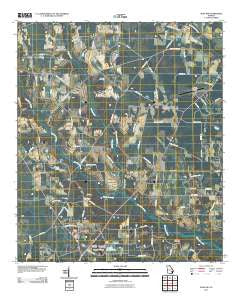
~ Alma NW GA topo map, 1:24000 scale, 7.5 X 7.5 Minute, Historical, 2011
Alma NW, Georgia, USGS topographic map dated 2011.
Includes geographic coordinates (latitude and longitude). This topographic map is suitable for hiking, camping, and exploring, or framing it as a wall map.
Printed on-demand using high resolution imagery, on heavy weight and acid free paper, or alternatively on a variety of synthetic materials.
Topos available on paper, Waterproof, Poly, or Tyvek. Usually shipping rolled, unless combined with other folded maps in one order.
- Product Number: USGS-5247321
- Free digital map download (high-resolution, GeoPDF): Alma NW, Georgia (file size: 14 MB)
- Map Size: please refer to the dimensions of the GeoPDF map above
- Weight (paper map): ca. 55 grams
- Map Type: POD USGS Topographic Map
- Map Series: US Topo
- Map Verison: Historical
- Cell ID: 660
- Datum: North American Datum of 1983
- Map Projection: Transverse Mercator
- Map Cell Name: Alma NW
- Grid size: 7.5 X 7.5 Minute
- Date on map: 2011
- Map Scale: 1:24000
- Geographical region: Georgia, United States
Neighboring Maps:
All neighboring USGS topo maps are available for sale online at a variety of scales.
Spatial coverage:
Topo map Alma NW, Georgia, covers the geographical area associated the following places:
- Mount Olive Baptist Church - Unity Church - Appling County Fire Department County Farm Station - Bar-O-Ranch Lake Dam - Tanner Lake - Bethel Free Will Baptist Church - Harrison Cemetery - Crosby Chapel United Methodist Church - Dyal Elementary School - Springfield Cemetery - Miles Chapel Cemetery - Unity Cemetery - Corinth United Methodist Church - Bishop Creek Structure Number Six Lake - New Hope Cemetery - Springfield Methodist Church - Midway Methodist Episcopal Church South (historical) - New Hope Church - Altman Cemetery - Miles Chapel Missionary Baptist Church - Appling Country Club - Sand Hill Creek Freewill Baptist Church - Bishop Creek - Big Creek Church - Bar-O-Ranch Lake - Bishop Creek Structure Number Six Dam - Big Satilla Creek Division - Big Creek Cemetery - Warnock Volunteer Fire Station - Tanner Lake Dam - Corinth Cemetery - Baxley Municipal Airport
- Map Area ID: AREA31.7531.625-82.5-82.375
- Northwest corner Lat/Long code: USGSNW31.75-82.5
- Northeast corner Lat/Long code: USGSNE31.75-82.375
- Southwest corner Lat/Long code: USGSSW31.625-82.5
- Southeast corner Lat/Long code: USGSSE31.625-82.375
- Northern map edge Latitude: 31.75
- Southern map edge Latitude: 31.625
- Western map edge Longitude: -82.5
- Eastern map edge Longitude: -82.375


