
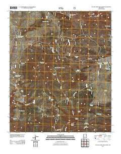
~ Canyon Creek Mountains NM topo map, 1:24000 scale, 7.5 X 7.5 Minute, Historical, 2011
Canyon Creek Mountains, New Mexico, USGS topographic map dated 2011.
Includes geographic coordinates (latitude and longitude). This topographic map is suitable for hiking, camping, and exploring, or framing it as a wall map.
Printed on-demand using high resolution imagery, on heavy weight and acid free paper, or alternatively on a variety of synthetic materials.
Topos available on paper, Waterproof, Poly, or Tyvek. Usually shipping rolled, unless combined with other folded maps in one order.
- Product Number: USGS-5244381
- Free digital map download (high-resolution, GeoPDF): Canyon Creek Mountains, New Mexico (file size: 24 MB)
- Map Size: please refer to the dimensions of the GeoPDF map above
- Weight (paper map): ca. 55 grams
- Map Type: POD USGS Topographic Map
- Map Series: US Topo
- Map Verison: Historical
- Cell ID: 7133
- Datum: North American Datum of 1983
- Map Projection: Transverse Mercator
- Map Cell Name: Canyon Creek Mountains
- Grid size: 7.5 X 7.5 Minute
- Date on map: 2011
- Map Scale: 1:24000
- Geographical region: New Mexico, United States
Neighboring Maps:
All neighboring USGS topo maps are available for sale online at a variety of scales.
Spatial coverage:
Topo map Canyon Creek Mountains, New Mexico, covers the geographical area associated the following places:
- Tincan Tank - Elk Mountains - Stovepipe Tank - Hulse Ranch - Prospector Tank - Indian Creek Water Well - Road Tank - Bonus Tank - Cooney Tank Number 3 - Upper Dutch Tank - Pine Tank - Bull Pass Canyon - Cooney Tank Number 2 - Turkey Spring Canyon - East Elk Mountain - Upper Cooney Tank - Cooney Prairie - Double Springs Ranch - Pine Canyon - Ten Cow Canyon - Oak Tank - Lower Canyon Creek Tank - Scrub Oak Tank - Christie Tank - Bull Pass Tank - Cooney Tank Number 1 - Chris Tank - Cooney Point - Lost Tank - Canyon Creek Mountains - Lower Dutch Tank - Gillette Tanks - Christie Canyon - Houghton Tank - Middle Canyon Creek Tank - East Elk Tank - Stovepipe Mesa - Little Turkey Spring - Indian Creek Well - Pine Tank - University Tank
- Map Area ID: AREA33.533.375-108.375-108.25
- Northwest corner Lat/Long code: USGSNW33.5-108.375
- Northeast corner Lat/Long code: USGSNE33.5-108.25
- Southwest corner Lat/Long code: USGSSW33.375-108.375
- Southeast corner Lat/Long code: USGSSE33.375-108.25
- Northern map edge Latitude: 33.5
- Southern map edge Latitude: 33.375
- Western map edge Longitude: -108.375
- Eastern map edge Longitude: -108.25


