
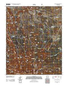
~ Cerro Pelon NM topo map, 1:24000 scale, 7.5 X 7.5 Minute, Historical, 2011
Cerro Pelon, New Mexico, USGS topographic map dated 2011.
Includes geographic coordinates (latitude and longitude). This topographic map is suitable for hiking, camping, and exploring, or framing it as a wall map.
Printed on-demand using high resolution imagery, on heavy weight and acid free paper, or alternatively on a variety of synthetic materials.
Topos available on paper, Waterproof, Poly, or Tyvek. Usually shipping rolled, unless combined with other folded maps in one order.
- Product Number: USGS-5244171
- Free digital map download (high-resolution, GeoPDF): Cerro Pelon, New Mexico (file size: 26 MB)
- Map Size: please refer to the dimensions of the GeoPDF map above
- Weight (paper map): ca. 55 grams
- Map Type: POD USGS Topographic Map
- Map Series: US Topo
- Map Verison: Historical
- Cell ID: 8027
- Datum: North American Datum of 1983
- Map Projection: Transverse Mercator
- Map Cell Name: Cerro Pelon
- Grid size: 7.5 X 7.5 Minute
- Date on map: 2011
- Map Scale: 1:24000
- Geographical region: New Mexico, United States
Neighboring Maps:
All neighboring USGS topo maps are available for sale online at a variety of scales.
Spatial coverage:
Topo map Cerro Pelon, New Mexico, covers the geographical area associated the following places:
- San Mateo Springs Tract Number Two - Laguna Largo - La Mosca Lookout Tower - Seco Tank - Frog Lake Tank - Colorado Tank - Ojo Piedra - Antelope Tank - American Tank - Cold Spring - Maruca Canyon - La Cuchilla - Lagunita Tank - Manuel Spring - Willow Spring - San Mateo Spring - George Tank - Spud Patch Canyon - Elkins Camp - Cold Spring Water Well - Fernandez Camp - Cerro Osha - Upper American Canyon Spring - Maruca Spring - Colorado Spring - Llanito Frio Tanks - Gobbler Spring - Elkins Spring - Sandoval Spring - Escondido Tank - Lower American Spring - Salazar Spring - Sheep Corral Stock Tank - Big Canyon Spring - San Lucas Spring - Cerro Venada - CCC Spring - Salazar Tank - Big Lake - Antelope Flats - Spruce Tank - Effran Tank - Cerro Pelon - Spud Patch - Corner Spring - Silt Tank - American Canyon - KLLT-FM (Grants) - La Cuchilla Pit Mine
- Map Area ID: AREA35.37535.25-107.625-107.5
- Northwest corner Lat/Long code: USGSNW35.375-107.625
- Northeast corner Lat/Long code: USGSNE35.375-107.5
- Southwest corner Lat/Long code: USGSSW35.25-107.625
- Southeast corner Lat/Long code: USGSSE35.25-107.5
- Northern map edge Latitude: 35.375
- Southern map edge Latitude: 35.25
- Western map edge Longitude: -107.625
- Eastern map edge Longitude: -107.5


