
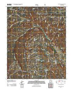
~ Canon Plaza NM topo map, 1:24000 scale, 7.5 X 7.5 Minute, Historical, 2011
Canon Plaza, New Mexico, USGS topographic map dated 2011.
Includes geographic coordinates (latitude and longitude). This topographic map is suitable for hiking, camping, and exploring, or framing it as a wall map.
Printed on-demand using high resolution imagery, on heavy weight and acid free paper, or alternatively on a variety of synthetic materials.
Topos available on paper, Waterproof, Poly, or Tyvek. Usually shipping rolled, unless combined with other folded maps in one order.
- Product Number: USGS-5242957
- Free digital map download (high-resolution, GeoPDF): Canon Plaza, New Mexico (file size: 30 MB)
- Map Size: please refer to the dimensions of the GeoPDF map above
- Weight (paper map): ca. 55 grams
- Map Type: POD USGS Topographic Map
- Map Series: US Topo
- Map Verison: Historical
- Cell ID: 7092
- Datum: North American Datum of 1983
- Map Projection: Transverse Mercator
- Map Cell Name: Canon Plaza
- Grid size: 7.5 X 7.5 Minute
- Date on map: 2011
- Map Scale: 1:24000
- Geographical region: New Mexico, United States
Neighboring Maps:
All neighboring USGS topo maps are available for sale online at a variety of scales.
Spatial coverage:
Topo map Canon Plaza, New Mexico, covers the geographical area associated the following places:
- Valle de los Caballos - Cañon Plaza - La Jara Canyon - La Manga Tank - Arroyo Plaza Tank - Felipito Canyon - Valle Grande Trail - La Manga Canyon - Hondo Canyon - La Jara Canyon Tank - Valle Diablo Tank - Burro Tank - Cañada Jacques - Jacques Canyon Tank Number 1 - Jaramillo Ranch (historical) - Cañada Llaves - Bonita Canyon - Cañada Escondida Tank - Ritito Canyon - Jacques Canyon Tank Number 2 - Cañada Burro - Cañada Gallina - Cañon de los Posos - El Ritito Tank - Cañada Escondia - Escondida Canyon Tank - Ensenada Lake - Rock Tank - Cañada Escondida - Cañada Alamosa - El Ritito Campground - Ojito Escondido Canyon - Cañada de Oso
- Map Area ID: AREA36.62536.5-106.25-106.125
- Northwest corner Lat/Long code: USGSNW36.625-106.25
- Northeast corner Lat/Long code: USGSNE36.625-106.125
- Southwest corner Lat/Long code: USGSSW36.5-106.25
- Southeast corner Lat/Long code: USGSSE36.5-106.125
- Northern map edge Latitude: 36.625
- Southern map edge Latitude: 36.5
- Western map edge Longitude: -106.25
- Eastern map edge Longitude: -106.125


