
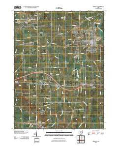
~ Orrville OH topo map, 1:24000 scale, 7.5 X 7.5 Minute, Historical, 2010
Orrville, Ohio, USGS topographic map dated 2010.
Includes geographic coordinates (latitude and longitude). This topographic map is suitable for hiking, camping, and exploring, or framing it as a wall map.
Printed on-demand using high resolution imagery, on heavy weight and acid free paper, or alternatively on a variety of synthetic materials.
Topos available on paper, Waterproof, Poly, or Tyvek. Usually shipping rolled, unless combined with other folded maps in one order.
- Product Number: USGS-5225634
- Free digital map download (high-resolution, GeoPDF): Orrville, Ohio (file size: 12 MB)
- Map Size: please refer to the dimensions of the GeoPDF map above
- Weight (paper map): ca. 55 grams
- Map Type: POD USGS Topographic Map
- Map Series: US Topo
- Map Verison: Historical
- Cell ID: 33483
- Datum: North American Datum of 1983
- Map Projection: Transverse Mercator
- Map Cell Name: Orrville
- Grid size: 7.5 X 7.5 Minute
- Date on map: 2010
- Map Scale: 1:24000
- Geographical region: Ohio, United States
Neighboring Maps:
All neighboring USGS topo maps are available for sale online at a variety of scales.
Spatial coverage:
Topo map Orrville, Ohio, covers the geographical area associated the following places:
- Smithville - Orrville - East Union - Whispering Pines Estates - Four T Mobile Home Park - Little Chippewa Estates - Five Points - Weilersville - Apple Creek - Orrville Trailer Park - Riceland - Glen Ridge Mobile Home Park - Wooster Rolling Wheels - Paradise (historical) - Millbourne Mobile Manor - Edinburgh - Auburn Estates
- Map Area ID: AREA40.87540.75-81.875-81.75
- Northwest corner Lat/Long code: USGSNW40.875-81.875
- Northeast corner Lat/Long code: USGSNE40.875-81.75
- Southwest corner Lat/Long code: USGSSW40.75-81.875
- Southeast corner Lat/Long code: USGSSE40.75-81.75
- Northern map edge Latitude: 40.875
- Southern map edge Latitude: 40.75
- Western map edge Longitude: -81.875
- Eastern map edge Longitude: -81.75


