
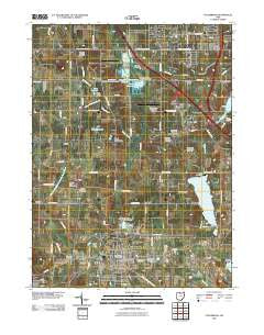
~ Columbiana OH topo map, 1:24000 scale, 7.5 X 7.5 Minute, Historical, 2010
Columbiana, Ohio, USGS topographic map dated 2010.
Includes geographic coordinates (latitude and longitude). This topographic map is suitable for hiking, camping, and exploring, or framing it as a wall map.
Printed on-demand using high resolution imagery, on heavy weight and acid free paper, or alternatively on a variety of synthetic materials.
Topos available on paper, Waterproof, Poly, or Tyvek. Usually shipping rolled, unless combined with other folded maps in one order.
- Product Number: USGS-5225012
- Free digital map download (high-resolution, GeoPDF): Columbiana, Ohio (file size: 15 MB)
- Map Size: please refer to the dimensions of the GeoPDF map above
- Weight (paper map): ca. 55 grams
- Map Type: POD USGS Topographic Map
- Map Series: US Topo
- Map Verison: Historical
- Cell ID: 9699
- Datum: North American Datum of 1983
- Map Projection: Transverse Mercator
- Map Cell Name: Columbiana
- Grid size: 7.5 X 7.5 Minute
- Date on map: 2010
- Map Scale: 1:24000
- Geographical region: Ohio, United States
Neighboring Maps:
All neighboring USGS topo maps are available for sale online at a variety of scales.
Spatial coverage:
Topo map Columbiana, Ohio, covers the geographical area associated the following places:
- Morgantown - Porters Corners - Shadybrook Mobile Home Park - Maplecroft Mobile Home Park - East Lewistown - Five Points - Beechwood Mobile Estates - Paradise - New Buffalo - Southern Terrace Park - Island - Willow Crest - Snyder (historical) - Woodworth - Columbiana - Boyer - Germantown - Eureka - Lynn Mobile Manor - North Lima - McClurg
- Map Area ID: AREA4140.875-80.75-80.625
- Northwest corner Lat/Long code: USGSNW41-80.75
- Northeast corner Lat/Long code: USGSNE41-80.625
- Southwest corner Lat/Long code: USGSSW40.875-80.75
- Southeast corner Lat/Long code: USGSSE40.875-80.625
- Northern map edge Latitude: 41
- Southern map edge Latitude: 40.875
- Western map edge Longitude: -80.75
- Eastern map edge Longitude: -80.625


