
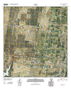
~ Citrus City TX topo map, 1:24000 scale, 7.5 X 7.5 Minute, Historical, 2010
Citrus City, Texas, USGS topographic map dated 2010.
Includes geographic coordinates (latitude and longitude). This topographic map is suitable for hiking, camping, and exploring, or framing it as a wall map.
Printed on-demand using high resolution imagery, on heavy weight and acid free paper, or alternatively on a variety of synthetic materials.
Topos available on paper, Waterproof, Poly, or Tyvek. Usually shipping rolled, unless combined with other folded maps in one order.
- Product Number: USGS-5157967
- Free digital map download (high-resolution, GeoPDF): Citrus City, Texas (file size: 18 MB)
- Map Size: please refer to the dimensions of the GeoPDF map above
- Weight (paper map): ca. 55 grams
- Map Type: POD USGS Topographic Map
- Map Series: US Topo
- Map Verison: Historical
- Cell ID: 8826
- Datum: North American Datum of 1983
- Map Projection: Transverse Mercator
- Map Cell Name: Citrus City
- Grid size: 7.5 X 7.5 Minute
- Date on map: 2010
- Map Scale: 1:24000
- Geographical region: Texas, United States
Neighboring Maps:
All neighboring USGS topo maps are available for sale online at a variety of scales.
Spatial coverage:
Topo map Citrus City, Texas, covers the geographical area associated the following places:
- Celso Colonia - Citrus City - Enrique Bazan Colonia - Abram North Colonia - Kountry Hill Estates Colonia - Goodwin Heights Number 1 Colonia - Basham Number 16 Colonia - La Paloma Site Colonia - Ramona Colonia - Mary K Acres Colonia - Orleander Estates Colonia - Munoz Estates Colonia - Western Estates Number 1 Colonia - Puerta Blanca Colonia - Reina Colonia - Salida del Sol Estates Colonia - Doffing - Palmarina Colonia - Daniel Ozuna Colonia - Basham Number 12 Colonia - El Flaco Chiquito Colonia - Acevedo Number 3 Colonia - Basham Number 13 Colonia
- Map Area ID: AREA26.37526.25-98.5-98.375
- Northwest corner Lat/Long code: USGSNW26.375-98.5
- Northeast corner Lat/Long code: USGSNE26.375-98.375
- Southwest corner Lat/Long code: USGSSW26.25-98.5
- Southeast corner Lat/Long code: USGSSE26.25-98.375
- Northern map edge Latitude: 26.375
- Southern map edge Latitude: 26.25
- Western map edge Longitude: -98.5
- Eastern map edge Longitude: -98.375


