
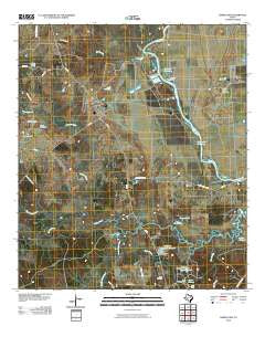
~ Baker Lake TX topo map, 1:24000 scale, 7.5 X 7.5 Minute, Historical, 2010
Baker Lake, Texas, USGS topographic map dated 2010.
Includes geographic coordinates (latitude and longitude). This topographic map is suitable for hiking, camping, and exploring, or framing it as a wall map.
Printed on-demand using high resolution imagery, on heavy weight and acid free paper, or alternatively on a variety of synthetic materials.
Topos available on paper, Waterproof, Poly, or Tyvek. Usually shipping rolled, unless combined with other folded maps in one order.
- Product Number: USGS-5139514
- Free digital map download (high-resolution, GeoPDF): Baker Lake, Texas (file size: 19 MB)
- Map Size: please refer to the dimensions of the GeoPDF map above
- Weight (paper map): ca. 55 grams
- Map Type: POD USGS Topographic Map
- Map Series: US Topo
- Map Verison: Historical
- Cell ID: 2176
- Datum: North American Datum of 1983
- Map Projection: Transverse Mercator
- Map Cell Name: Baker Lake
- Grid size: 7.5 X 7.5 Minute
- Date on map: 2010
- Map Scale: 1:24000
- Geographical region: Texas, United States
Neighboring Maps:
All neighboring USGS topo maps are available for sale online at a variety of scales.
Spatial coverage:
Topo map Baker Lake, Texas, covers the geographical area associated the following places:
- State Ferry (historical) - Ferguson Reservoir Dam Number 1 - Lake Palomas Dam - Lake Palomas - Cedar Creek - Texas Department of Criminal Justice Jim Ferguson Unit - Hopewell School - Eastham Levee - Marks Lake - Pine Branch - South Bedias Creek - Falba Cemetery - Carson Lake - Marks Lake Dam - Shaw Prairie School - Salt Branch - Lake Picidae Dam - Ford Lake - Bald Prairie - Lake Picidae - Texas Department of Criminal Justice Eastham Unit - Baker Lake - Cedar Branch - Ferguson Reservoir Number 1 - Kay Branch - Black Oak Branch - Larrison Creek - Pollard Branch - Bar O Ranch - Eastham Reservoir
- Map Area ID: AREA3130.875-95.75-95.625
- Northwest corner Lat/Long code: USGSNW31-95.75
- Northeast corner Lat/Long code: USGSNE31-95.625
- Southwest corner Lat/Long code: USGSSW30.875-95.75
- Southeast corner Lat/Long code: USGSSE30.875-95.625
- Northern map edge Latitude: 31
- Southern map edge Latitude: 30.875
- Western map edge Longitude: -95.75
- Eastern map edge Longitude: -95.625


