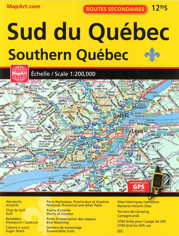
Southern Québec Back Road Atlas by Canadian Cartographics Corporation
This GPS Compatible 2016 Back Road Atlas features: Aeroports/Airports, Club de Golf/Golf, Belvedere Viewpoint/Lookout, Cabane a sucre/Sugar Shack, Parcs Nationaux, Provinciaux et dautres/ National Provincial and other Parks, Points dinteret/Points of interest, Point dobservation des oisewux/Bird Watching, Sentiers de motomeige/Snowmobile trails, Sites Historiques nationaux/ National Historic Sites, Terrains de Camping/Campgrounds, UTM Grille pour lusage de GPS/UTM Grid for GPS use and ZEC Coverage: 1:200,000 Regional Mapping of the southern portion of Quebec Province. Coverage includes, but is not limited to: Petawawa & Cornwall to the West, Southern portions of Outaouais, Laurentides, Lanaudiere, Mauricie , Charlevoix, Chaudiere-Appalaches, Cantons-de-lEst and Monteregie. Coverage of Northeastern USA along the border. Coverage of Ottawa-Montreal-Quebec City corridor including areas north & south of this corridor.
- Product Number: 2213987
- Product Code: CCC_QUE_S_AT
- ISBN: 9781554861385
- Year of Publication: 2016
- Unfolded Size: 11.02 x 8.66 inches
- Map type: Atlas
- Geographical region: Quebec