
Rocky Mountain National Park, Map Pack Bundle by National Geographic Maps
• Waterproof • Tear-Resistant • Topographic Map
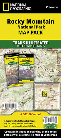
Seeking the best combination of detailed maps and value for your Rock Mountain National Park trip? Then get our bundle pack. It includes both our Rocky Mountain National Park (folded size: 23.5 x 10.5 cm) and Longs Peak (19 x 10 cm) Trails Illustrated maps, providing you coverage of the entire map region, while saving you over 15%. Like all Trails Illustrated maps, the Rocky Mountain National Park Bundle set is frequently revised and printed on waterproof, tear-resistant material to stand up to all conditions. This detailed topographic recreation map bundle contains carefully researched trails, campsites, forest service roads, and points-of-interests. Includes UTM grids for use with your GPS unit.
Coverage includes: Rocky National Park, Longs Peak, Bear Lake, Arapaho and Roosevelt National Forests, Never Summer Wilderness, Arapaho National Recreation Area, and the cities of Granby and Estes Park and more.
contains maps (ML codes):
2029319M
2034578M
- Product Number: 2060063M
- Product Code: TI_ROCKY_PK
- Publisher Product ID: TI01020585B
- ISBN: 9781597754071
- Year of Publication: 2008
- Folded Size: 9.45 x 4.33 inches
- Unfolded Size: 24.8 x 33.07 inches
- Map type: Folded Map
- Geographical region: Colorado


