
California Map, San Diego Surfing, laminated, 2007 by Frankos Maps Ltd.
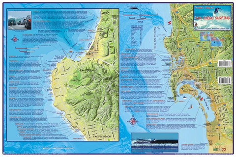
Frankos Map of San Diego Surfing Side 1 shows Frankos Map of San Diego Surfing South, since it begins at about Del Mar and goes down to the Mexican Border, plus it shows a big inset with close-up details of everything from Blacks Beach to Pacific Beach. Of course, La Jolla Shores, Hospitals, Horseshoes, Windandsea, Big Rock, Bird Rock, PB Point, PB, Mission Beach, Ocean Beach, Sunset Cliffs, Point Loma, Coronado Island, Silver Strand, Imperial Beach, and even Tijuana Sloughs is included, with many, many more. The major roads and freeways of San Diego County are shown to guide the surfer to these spots as well. There are a few interesting photos on side one as well, including a very unique photo at La Jolla cove, where a surfer on a giant wave appears to be above the cars along the street. Each description explains the best surfing condition, the nature of the break, best time of year, best swell direction, tide height, wind direction, and other details of importance to the surfer.
- Product Number: 2042495M
- Product Code: FM_SAN_DI_SUR_LAM
- ISBN: 9781601901842
- Year of Publication: 2007
- Unfolded Size: 13.39 x 20.47 inches
- Map type: Flat Map
- Geographical region: California


