
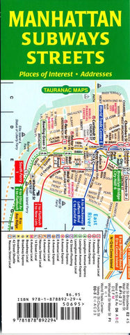
Manhattan Subways and Streets by Tauranac Press
This pair of maps shows you how to find the closest subway station from where you are, and which subway takes you to the most convenient station that will get you to your ultimate destination. The street map includes house numbers, neighborhoods, tourist attractions, museums and other places of interest. There is an index of subway stations with the daily service at each station, an index of streets, and an index of places of interest. Both maps are to the same scale and have the same grid coordinates. Plus theres a late-night subway map.
True to Tauranacs belief that a transportation map should be more didactic than merely indicating full-time v. part-time service, the service on his maps is time specific - a red number or letter indicates that the service only operates weekdays, blue indicates that the service only operates rush hours, and so on.
Folded, the maps measure 3.3 by 8.3 inches, a comfortable size for pocket, purse, tote or backpack. Unfolded - and accordion folds make folding and unfolding a snap - the maps measure 26.4 by 8.3 inches. The odds are that you probably wont have to look at more than four panels at a time - say, from the Battery to 86th Street - to plan your trip.
The maps are printed on heavy stock and are lightly laminated.
- Product Number: 2042422M
- Product Code: TAU_MAN_SUBSTR
- ISBN: 9781878892294
- Year of Publication: 2011
- Folded Size: 8.27 x 3.15 inches
- Unfolded Size: 25.2 x 6.89 inches
- Map type: Folded Map
- Geographical region: New York


