
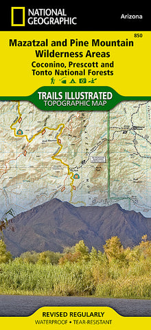
Mazatzal and Pine Mountain Wilderness Areas, Map 850 by National Geographic Maps
waterproof, tear-Resistant, topographic map
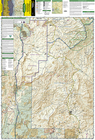
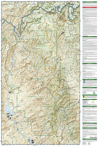
Outdoor enthusiasts looking for recreational opportunities just north of Phoenix, will marvel at National Geographics Trails Illustrated map of Mazatzal and Pine Mountain Wilderness Areas. Expertly researched and created in cooperation with the U.S. Forest Service, Bureau of Land Management and others, the map covers these wilderness areas in Coconino, Prescott, and Tonto National Forests with unmatched detail. Some of the regions popular recreation spots detailed include Agua Fria National Monument, Verde Wild and Scenic River, Mogollon Rim, Bartlett and Horseshoe Reservoirs, Mazatzal Peak and Mountains, Spur Cross Ranch Conservation Area and Tonto Natural Bridge State Park.
Whether you enjoy recreation on foot, bike, horseback or motorized vehicle, mapped trails that are color-coded according to their designated usage will lead you on your exploration. The Arizona, Great Western and Maricopa Trails are all clearly labeled. To aid in your navigation, the map also features contour lines, elevations, labeled peaks and summits, selected waypoints, areas of wooded cover, clear boundaries between different land management agencies. Additional recreation points of interest covered include campgrounds, RV campgrounds, horse camps, trailheads, interpretive trails, fishing areas, boat launches and river access points. The map also provides background information for many of the areas recreation spots, recreation guidelines, safety tips and essential contact information.
Every Trails Illustrated map is printed on Backcountry Tough waterproof, tear-resistant paper. A full UTM grid is printed on the map to aid with GPS navigation.
Other features found on this map include: Coconino National Forest, Fossil Springs Wilderness, Horseshoe Reservoir, Humboldt Mountain, Mazatzal Wilderness, Mogollon Rim, New River Mountains, North Peak, Pine Mountain Wilderness, Prescott National Forest, Tonto National Forest.
- Product Number: 2034533M
- Product Code: TI_MAZATAL
- Publisher Product ID: TI00000850
- ISBN: 9781566954747
- Year of Publication: 2009
- Folded Size: 9.45 x 4.33 inches
- Unfolded Size: 33.07 x 24.8 inches
- Map type: Folded Map
- Geographical region: Arizona


