
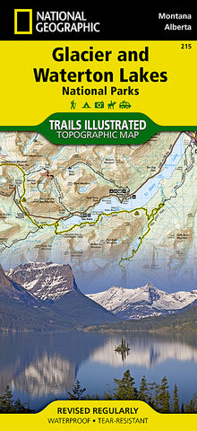
Glacier and Waterton Lakes National Parks, Map 215 by National Geographic Maps
• Waterproof • Tear-Resistant • Topographic Map
National Geographics Trails Illustrated map of Glacier and Waterton Lakes National Parks offers extensive detail for outdoor enthusiasts exploring the pristine landscape of forests, mountains, lakes, and meadows within these two spectacular parks. Created in partnership with local land management agencies, this expertly researched map features key areas of interest including Many Glacier, Great Bear Wilderness, Flathead National Forest, Hungry Horse Reservoir, Lake McDonald, Flathead River, St. Mary Lake, Akamina-Kishinena Provincial Park, and the Waterton Lakes.
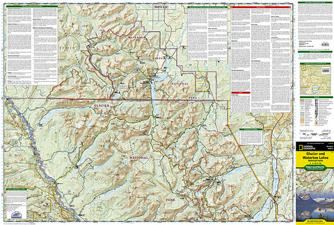
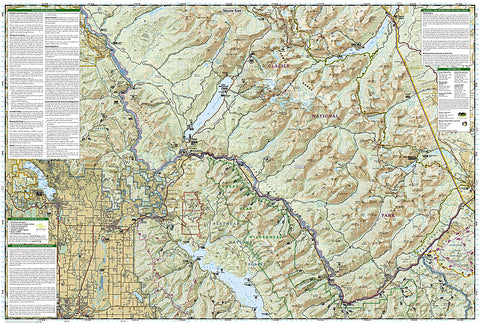
The Glacier and Waterton Lakes map is an invaluable resource for exploring the more than 800 miles of mapped trails within the parks, including the Pacific Northwest Trail, the Continental Divide Trail, and recommended biking trails. Recreation features are clearly marked, including campgrounds, trailheads, interpretive trails, fishing and boat access, and horse rental locations. The map base includes contour lines and elevations for summits, passes and major lakes. A variety of helpful information about recreation activities available in the parks, hiking and backcountry camping, regulations, and safety tips are included as well.
Every Trails Illustrated map is printed on Backcountry Tough waterproof, tear-resistant paper. A full UTM grid is printed on the map to aid with GPS navigation.
Other features found on this map include: Apgar, Apgar Mountains, Babb, Bowman Lake, Columbia Falls, Coram, East Glacier Park, Essex, Flathead Range, Glacier National Park, Hungry Horse, Kintla Lake, Kiowa, Lake McDonald, Lake McDonald, Lake Sherburne, Lewis Range, Livingston Range, Lower Saint Mary Lake, Mount Carter, Mount Cleveland, Mount Saint Nicholas, Mount Stimson, Pinnacle, Polebridge, Saint Mary, Saint Mary Lake, Upper Waterton Lake, West Glacier, Waterton Lakes National Park, Whitefish, Whitefish Lake, Montana, British Columbia, Alberta.
Map Scale = 1:100,000
- Product Number: 2034506M
- Product Code: TI_GLACIER
- Publisher Product ID: TI00000215
- ISBN: 9781566953184
- Year of Publication: 2009
- Folded Size: 9.45 x 4.330 inches
- Unfolded Size: 24.8 x 36.61 inches
- Map type: Folded Map
- Geographical region: Montana


