
Mississippi, Physical, Laminated Wall Map by Raven Maps
Detailed physical wall map of Mississippi State at a scale of 1:500,000. Laminated.
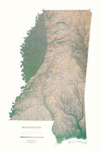
The cartography shows relief through a stunning, highly detailed shading, with different elevations varying in color, giving an almost 3-dimensional feel to the map. Peak heights are also clearly marked.
The map displays land only within the boundaries of the chosen states - there is no overlap with neighboring states. Principal physical features such as glaciers, mountain ranges, rivers and lakes are shown clearly. Human features, such as main towns, cities, roads and railways, are shown in a very fine, subtle and elegant cartographic style. State capitals are also clearly marked.
This map measures 122 x 82cm (48 x 32). Between the winding Mississippi and Yazoo rivers lies a fertile delta, and east of the Yazoo are the Pearl, the Big Black, and the Pascagoula River drainages. The sandy hills of the northeast give way to pine woods, prairie, and finally the Gulf Coast.
- Product Number: 2030679M
- Product Code: RP_MS_LA
- ISBN: 9780783433110
- Year of Publication: 1999
- Map type: Wall Map
- Geographical region: Mississippi


