
Antietam National Battlefield, Maryland, 1862 by McElfresh Map Co.
The true watershed battle of the Civil War. Had Robert E. Lee won, foreign intervention might have resulted in Confederate independence.
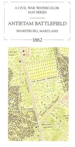
Style: Watercolor and colored pencil map showing crops, fences, houses, farms, watercourses, woods and significant terrain. No troop movements depicted. One side of the map features Morning Antietam Battlefield, Sharpsburg, Maryland, 1862 and represents the northern half of the field. The reverse side features: Afternoon Antietam Battlefield, Sharpsburg, Maryland 1862 and represents the southern half of the field. Text: The text includes a monograph describing the Maryland campaign and its Battle of Antietam. Packaged in a reusable sleeve.
- Product Number: 2030568M
- Product Code: MEM_ANTIETAM
- ISBN: 9780783416717
- Year of Publication: 1993
- Folded Size: 9.06 x 3.94 inches
- Unfolded Size: 14.17 x 18.9 inches
- Map type: Folded Map
- Geographical region: Maryland


