
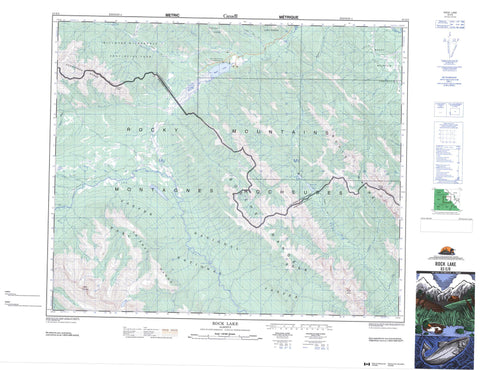
083E08 Rock Lake Canada topo map, 1:50,000 scale
083E08 Rock Lake NRCAN topographic map.
Includes UTM and GPS geographic coordinates (latitude and longitude). This 50k scale map is suitable for hiking, camping, and exploring, or you could frame it as a wall map.
Printed on-demand using high resolution, on heavy weight and acid free paper, or as an upgrade on a variety of synthetic materials.
Topos available on paper, Waterproof, Poly, or Tyvek. Usually shipping rolled, unless combined with other folded maps in one order.
- Product Number: NRCAN-083E08
- Parent Topo: TOPO-083E
- Map ID also known as: 083E08, 83E8, 83E08
- Unfolded Size: Approximately 26" high by 36" wide
- Weight (paper map): ca. 55 grams
- Map Type: POD NRCAN Topographic Map
- Map Scale: 1:50,000
- Geographical region: Alberta, Canada
Neighboring Maps:
All neighboring Canadian topo maps are available for sale online at 1:50,000 scale.
Purchase the smaller scale map covering this area: Topo-083E
Spatial coverage:
Topo map sheet 083E08 Rock Lake covers the following places:
- Snake Indian Falls - Busby Lake - Moosehorn Lake - Rock Lake - Aeolus Mountain - Berland Range - Bosche Range - Boule Range - Daybreak Peak - De Smet Range - Hoff Range - Hoff Ridge - Mount Aeolus - Mount Kephala - Mount Stornoway - Persimmon Range - Rocky Mountain Foothills - Rocky Mountains - Municipal District of Yellowhead No. 94 - Yellowhead County - Improvement District No. 12 - Improvement District No. 25 - Yellowhead Improvement District No. 14 - Jasper National Park of Canada - Parc national du Canada Jasper - Rock Lake Provincial Park - Willmore Wilderness Provincial Park - Carson Creek - Deer Creek - Forty-one Mile Creek - Girvan Creek - Ice Water Creek - Jackson Creek - Kephala Creek - Levi Creek - Moosehorn Creek - Mowitch Creek - Mumm Creek - Rock Creek - Seep Creek - Sheba Creek - Snake Indian River - Solomon Creek - Wildhay River - Willow Creek - Deer Creek Trail - Eagles Nest Trail - Grave Flats Trail - Moosehorn Trail - Mountain Trail - Mumm Creek Trail


