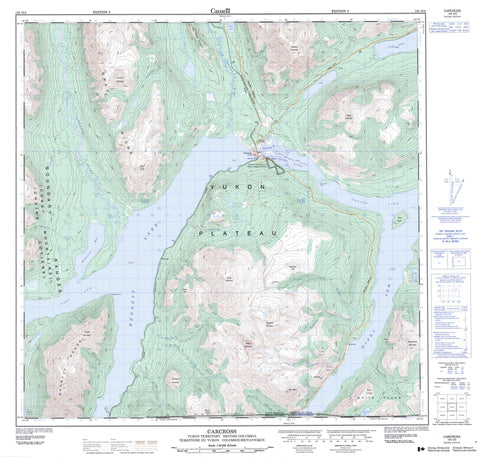
105D02 Carcross Canada topo map, 1:50,000 scale
105D02 Carcross NRCAN topographic map.
Includes UTM and GPS geographic coordinates (latitude and longitude). This 50k scale map is suitable for hiking, camping, and exploring, or you could frame it as a wall map.
Printed on-demand using high resolution, on heavy weight and acid free paper, or as an upgrade on a variety of synthetic materials.
Topos available on paper, Waterproof, Poly, or Tyvek. Usually shipping rolled, unless combined with other folded maps in one order.
- Product Number: NRCAN-105D02
- Parent Topo: TOPO-105D
- Map ID also known as: 105D02, 105D2
- Unfolded Size: Approximately 26" high by 36" wide
- Weight (paper map): ca. 55 grams
- Map Type: POD NRCAN Topographic Map
- Map Scale: 1:50,000
- Geographical region: Yukon, Canada
Neighboring Maps:
All neighboring Canadian topo maps are available for sale online at 1:50,000 scale.
Purchase the smaller scale map covering this area: Topo-105D
Spatial coverage:
Topo map sheet 105D02 Carcross covers the following places:
- Grayling Bay - Millhaven Bay - West Arm - Windy Arm - Prejevalsky Point - Ten Mile Point - Nàtàse Hîn - Carcross 4 - Bove Island - Bennett Lake - Crag Lake - Munroe Lake - Nares Lake - Old Lady Lake - Spirit Lake - Tagish Lake - Bennett Mountains - Bennett Range - Boundary Ranges - Brute Mountain - Caribou Mountain - Chaîne Côtière - Coast Mountains - Dail Peak - Dundalk Mountain - Escarpment Mountain - Finger Mountain - Gray Ridge - Knob Hill - Montana Mountain - Mount Dean - Mount Gray - Mount Matheson - Nares Mountain - Pyramid Mountain - Sugarloaf Hill - Surprise Mountain - Watson Ridge - White Range - Yukon Plateau - British Columbia - Colombie-Britannique - Big Thing Creek - Carls Creek - Dundalk Creek - Knob Creek - Lime Creek - McDonald Creek - Millhaven Creek - Montana Creek - Nares River - Pooly Creek - Racine Creek - Ramshorn Creek - Stevens Creek - Wabona Creek - Watson River - Wheaton River - Wynton Creek - Yukon - Carcross - Conrad - Dundalk - Watson - Copper Gulch - Corwin Valley - North Canyon - Pooly Canyon