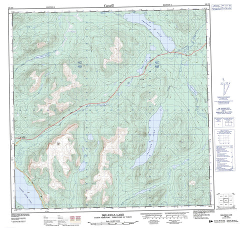
105C05 Squanga Lake Canada topo map, 1:50,000 scale
105C05 Squanga Lake NRCAN topographic map.
Includes UTM and GPS geographic coordinates (latitude and longitude). This 50k scale map is suitable for hiking, camping, and exploring, or you could frame it as a wall map.
Printed on-demand using high resolution, on heavy weight and acid free paper, or as an upgrade on a variety of synthetic materials.
Topos available on paper, Waterproof, Poly, or Tyvek. Usually shipping rolled, unless combined with other folded maps in one order.
- Product Number: NRCAN-105C05
- Parent Topo: TOPO-105C
- Map ID also known as: 105C05, 105C5
- Unfolded Size: Approximately 26" high by 36" wide
- Weight (paper map): ca. 55 grams
- Map Type: POD NRCAN Topographic Map
- Map Scale: 1:50,000
- Geographical region: Yukon, Canada
Neighboring Maps:
All neighboring Canadian topo maps are available for sale online at 1:50,000 scale.
Purchase the smaller scale map covering this area: Topo-105C
Spatial coverage:
Topo map sheet 105C05 Squanga Lake covers the following places:
- Cabin Lake - Dalayee Lake - Little Atlin Lake - Little Squanga Lake - Seaforth Lake - Squan Lake - Squanga Lake - Summit Lake - Wolf Lake - Mount White - Yukon Plateau - Hall Creek - Haunka Creek - Johns Creek - Johns Creek - Judas Creek - Little Atlin Creek - Seaforth Creek - Squanga Creek - Stony Creek - Teenah Creek - Teslin River - Jakes Corner