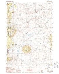
~ Sundance East WY topo map, 1:24000 scale, 7.5 X 7.5 Minute, Historical, 1984, updated 1985
Sundance East, Wyoming, USGS topographic map dated 1984.
Includes geographic coordinates (latitude and longitude). This topographic map is suitable for hiking, camping, and exploring, or framing it as a wall map.
Printed on-demand using high resolution imagery, on heavy weight and acid free paper, or alternatively on a variety of synthetic materials.
Topos available on paper, Waterproof, Poly, or Tyvek. Usually shipping rolled, unless combined with other folded maps in one order.
- Product Number: USGS-5616146
- Free digital map download (high-resolution, GeoPDF): Sundance East, Wyoming (file size: 12 MB)
- Map Size: please refer to the dimensions of the GeoPDF map above
- Weight (paper map): ca. 55 grams
- Map Type: POD USGS Topographic Map
- Map Series: HTMC
- Map Verison: Historical
- Cell ID: 43805
- Scan ID: 341568
- Imprint Year: 1985
- Woodland Tint: Yes
- Aerial Photo Year: 1980
- Edit Year: 1984
- Field Check Year: 1982
- Datum: NAD27
- Map Projection: Transverse Mercator
- Provisional map: Yes
- Map published by United States Geological Survey
- Map Language: English
- Scanner Resolution: 600 dpi
- Map Cell Name: Sundance East
- Grid size: 7.5 X 7.5 Minute
- Date on map: 1984
- Map Scale: 1:24000
- Geographical region: Wyoming, United States
Neighboring Maps:
All neighboring USGS topo maps are available for sale online at a variety of scales.
Spatial coverage:
Topo map Sundance East, Wyoming, covers the geographical area associated the following places:
- Crook County Fire Department - Medicine Lake - Black Hills National Forest Bearlodge Ranger District Fire Engine Crew - Sundance Division - Bear Lodge District Mine - Wyoming Highway Patrol District 1 Division Q - Mount Lewisa - Silver Creek - Medicine Flat Creek - South Fork Ogden Creek - Crook County Medical Services District Hospital - Government Valley Mine - Sundance Elementary School - Ogden Creek - Washington Park - Sundance Volunteer Fire Department - Sugarloaf - Green Mountain Cemetery - Town of Sundance - Crook County Medical Services - Sundance Emergency Medical Services - Medicine Flat - Green Mountain - Warner Springs Creek - Watson Pit Mine
- Map Area ID: AREA44.544.375-104.375-104.25
- Northwest corner Lat/Long code: USGSNW44.5-104.375
- Northeast corner Lat/Long code: USGSNE44.5-104.25
- Southwest corner Lat/Long code: USGSSW44.375-104.375
- Southeast corner Lat/Long code: USGSSE44.375-104.25
- Northern map edge Latitude: 44.5
- Southern map edge Latitude: 44.375
- Western map edge Longitude: -104.375
- Eastern map edge Longitude: -104.25