
~ La Crosse WI topo map, 1:250000 scale, 1 X 2 Degree, Historical, 1965, updated 1965
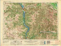
La Crosse, Wisconsin, USGS topographic map dated 1965.
Includes geographic coordinates (latitude and longitude). This topographic map is suitable for hiking, camping, and exploring, or framing it as a wall map.
Printed on-demand using high resolution imagery, on heavy weight and acid free paper, or alternatively on a variety of synthetic materials.
Topos available on paper, Waterproof, Poly, or Tyvek. Usually shipping rolled, unless combined with other folded maps in one order.
- Product Number: USGS-6005767
- Free digital map download (high-resolution, GeoPDF): La Crosse, Wisconsin (file size: 13 MB)
- Map Size: please refer to the dimensions of the GeoPDF map above
- Weight (paper map): ca. 55 grams
- Map Type: POD USGS Topographic Map
- Map Series: HTMC
- Map Verison: Historical
- Cell ID: 68862
- Scan ID: 503706
- Imprint Year: 1965
- Woodland Tint: Yes
- Aerial Photo Year: 1958
- Field Check Year: 1958
- Datum: NAD27
- Map Projection: Transverse Mercator
- Map published by United States Army Corps of Engineers
- Map published by United States Army
- Map Language: English
- Scanner Resolution: 508 dpi
- Map Cell Name: La Crosse
- Grid size: 1 X 2 Degree
- Date on map: 1965
- Map Scale: 1:250000
- Geographical region: Wisconsin, United States
Neighboring Maps:
All neighboring USGS topo maps are available for sale online at a variety of scales.
Spatial coverage:
Topo map La Crosse, Wisconsin, covers the geographical area associated the following places:
- Sattre - Muscoda - Shepardson's Park - Charme - Genoa - Wyoming - Green Lea Mobile Home Park - Dalby - Rushford - Watson - Hickory Grove - Waukon - Pickwick - Herrington - Liberty - Scotts Junction - Leon - Tomah - Aubrey - Wilton - Woodstock - Mid Town Mobile Home Park - Folsom - Pleasant Ridge - Middle Ridge - Elon - Readstown - Oakdale - Eastman - Bridgeport - McGregor Heights - Wonewoc - Waterville - Centerville - Festina - Utica - Dakota - Sextonville - Yankeetown - Reedsburg - West Lima - Towerville - Plain - Giard - Rockbridge - Witoka - Conover - Rux Mobile Home Park - Hustler - Marquette - Lone Rock - Dilly - Volney - Johnstown - Sugar Grove - McGregor - Port Andrew - Sparta - Eastside Mobile Home Park - Steuben - New Albin - Richland Center - Twin Bluffs - Plugtown - Maple Grove - Decorah - Sand Prairie - Erickson Trailer Court - Kelly - Freeburg - Harpers Ferry - Maud - Lewiston - Corwin (historical) - Westport - Village Creek - Harmony Hill - Trippville - Dresbach - Lakeview (historical) - Reed - De Soto - Pine Estates - Orion - Pine Creek - Yucatan - Benson's Mobile Home Park - Portland - Sabin - Rising Sun - Orange Mill - Yellow River - Bluffview Park Mobile Home Park - Brice Prairie - Mill Creek (historical) - Woodman - Rockland - Thunderbird Mobile Home Park - Angelo - Rolling Ground
- Map Area ID: AREA4443-92-90
- Northwest corner Lat/Long code: USGSNW44-92
- Northeast corner Lat/Long code: USGSNE44-90
- Southwest corner Lat/Long code: USGSSW43-92
- Southeast corner Lat/Long code: USGSSE43-90
- Northern map edge Latitude: 44
- Southern map edge Latitude: 43
- Western map edge Longitude: -92
- Eastern map edge Longitude: -90


